Beekeepers' Institute Site and Landscape Strategy
Planning of the Beekeepers Institute is part of a group of institutions inside of the now disused Crystal Palace Park. In addition to the beekeepers, there are several other interest groups that use the vestiges of the Crystal Palace Park as a location for their activities. These activity groups include the following;
-The British Caravaners Society
-The Crystal Palace Foundation
-The British Botanical Society
-The British Paleontologists Society
-The British Race-car Association
-The Sports Exposition Authority
-The Crystal Palace Exotic Animal Petting Zoo
-The British Railway Museum
-The British Anglers Society
-Roseberry's Fine Art
There is also a lengthy list of park features that are considered by many to be institutions in and of themselves;
1. Grand Central Walk: Originally 2,660ft long, 96ft wide and linking up to the Palace building, the Grand Centre Walk now only extends up to the steps of the National Sports Centre. During the Festival of Empire in 1911, three-quarter size replicas of all the principal Parliament buildings were reconstructed at this point on the Walk.
2. Old Cricket Pavilion: A late 19th century building stood on this site until 1960. It was used by the famous cricketer Dr WG Grace (1848-1915), who would walk over to play his matches from his home, ‘Parklands’, sited on Crystal Palace Park Road. Dr Grace was player and manager of the London County Cricket Club based at Crystal Palace.
3. H.M.S Crystal Palace: This timber structure and ship’s bell, originally sited on the lower terrace, became affectionately known as ‘HMS Crystal Palace’ when it was occupied by 125,000 men during the First World War. A tablet records its unveiling by the then Prince of Wales in 1931.
4. Airpowered Railway: During 1864, TW Rammell opened an experinlental 600-yard pneumatic or air-powered passenger-carrying railway between the Sydenham and Penge entrances. It was operated by a steam engine, which blew or sucked the train along the track. The 50-second journey cost 6d (old pence) and the single carriage held a maximum of 35 passengers.
5. The Vale: A former Neo-Gothic villa named ‘The Vale’ occupied this site from 1880 until it was demolished and became overgrown after 1977. In an attempt to recreate its former grandeur, the railings have been put back and the frontage walls re-built using most of the original bricks.
6. The Race Track: Until 1973, the former motor-racing circuit was used by such greats as Stirling Moss, Jack Brabham and many others. In 1927, the first motorcycles raced around the pathways of Crystal Palace and, in 1953, a new Crystal Palace circuit was reopened for motor racing.
7. Football: This is where the first ever F.A Cup Final was held in 1895. In addition to the Cup Finals, the Palace played host to England-v-Scotland Internationals played every four years from 1897.
8. The Maze: The Crystal Palace Park circular Tea Maze is not only London’s largest maze, but also one of the biggest in the country, being 160ft in diameter and occupying a total area of nearly 2000 square yards. It has been fully rebuilt by the London Borough of Bromley as an exact replica of the original that fell into disuse during the Second World War.
9. The Concert Bowl: This area of the park was used as part of the Pageant of London during the Festival of Empire in 1911. The natural amphitheatre created by the landform has excellent acoustic properties. There is an original statue from Crystal Palace in front of the terrace wall, which depicts 'Dante’, the Italian poet.
10. Fireworks and Fun: This was known as the Italian Gardens and was the scene of many a spectacular display of fireworks. The first display took place in 1865 and continued up until 1936, becoming world renowned by the turn of the twentieth century. The current-day fireworks are centred around a grand November 5th public display in aid of charity.
10a. Orangery/North Wing: This repository for an orange grove, known as the Orangery, was constructed in 1854 as an annexe to the North Wing. The structure was finally demolished in the early 1950’s. The original wall to the Orangery can still be seen, the archway being part of an entrance into the greenhouse area.
11. Paxton’s Bust: Donated by public subscription and unveiled at a Fete in June 1873, this was to mark the 20th year of the Palace and to show appreciation for the master architect. The bust originally looked towards the Palace building over the central pool (now the car park) but has been re-sited and turned to survey the park.
11a. Italian Terraces: The retaining wall, steps and other features of both upper and lower terraces survive largely intact and are Grade II listed. There were statues on each of the plinths depicting the national dress from countries of the Empire, of which one remains intact. The Sphinxes on the Upper Terraces were copied from an Egyptian original in the Louvre and are made of a brick shell.
11b. South Nave: The South Nave housed the Natural History Exhibition and the splendid "Screens of the Kings and Queens of England". One of the original statues from Crystal Palace (a nymph) now sits where the magnificent Follett Osler’s Crystal Palace Fountain once stood. Thhis was 27 feet high and made of 4 tons of the best quality glass.
12. Museum: The museum is situated in the former Crystal Palace School of Engineering, established in 1872 and the only building left after the fire of 1936. Outside the museum, alongside the base of Brunel’s 284ft water tower, is an original 1852 column. The Crystal Palace Museum, run by an independent trust, is only open to the public on Sundays and Bank Holiday Mondays from 2.00 - 5.00pm.
13. Low Level Railway Station: The line and station were specifically built for the visitors to the Palace and grounds, and were opened on the 10th June 1854. The Crystal Palace look-alike station operationally replaced the old building in 1986.
14. South Basin Pool-Water Features: The South Basin Pool, which now houses flamingos, is the last surviving element of Paxton’s extensive water displays. The area of the National Sports Centre to the left was where the lower basin was situated. The water basins supported two 250ft high fountains and, originally, there were over 100 miles of underground pipes using 120,000 gallons of water per minute supplying 11,788 individual jets.
15. Geological Strata-Paxton Bridge: As part of the Victorians’ love of Education, this area of the park was reserved for ‘Geology and Inhabitants of the Ancient World’. The original cliffs included mountain limestone, millstone grit, ironstone and new sandstone. To the left was a model of a Derbyshire lead mine, complete with pipe veins, rake veins and stalactites and with life-size models of Irish Elks above the entrance.
16. Prehistoric Monsters: The prehistoric monsters, 33 in total, were built in 1854 under the guidance of Professor Richard Owen, who invented the word ‘dinosaur’. These first-ever full-size dinosaurs were created by Benjamin Waterhouse Hawkins, an expert on geology and extinct animals, who constructed the models based on fossils kept in the British Museum. It is now known, however, that many errors were made, especially in Owen’s masterpiece, the Iguanodon. The Iguanodon's rhinoceros-type horn located on the its nose was, in fact, a kind of spiky thumb.
17. Boating Lake: Constructed as the lower reservoir, the boating lake was also known as the ‘Tidal Lake’. When Paxton’s full system of waterworks was in operation, the level of the lake was subject to great changes, being low when water was drawn off to feed the fountains and high when the water was returned. People still enjoy the use of the boating lake to the present day.
Demolition before New Construction- a pattern of practice at Crystal Palace- to be repeated in this proposal to reconstitute park institutions;
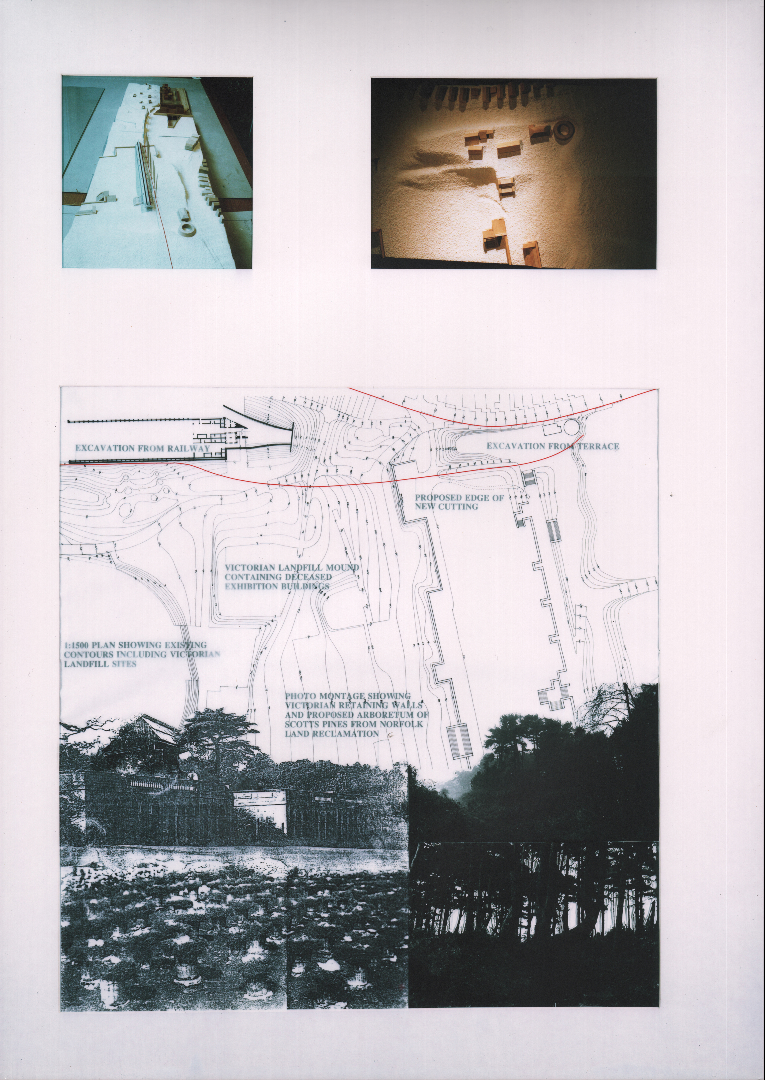
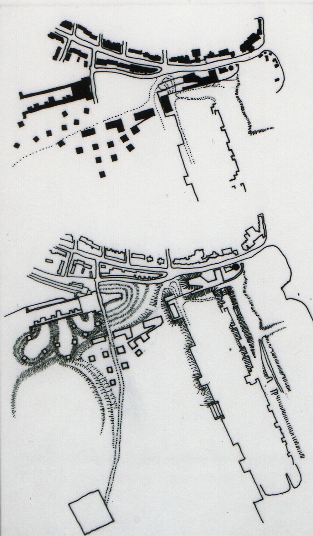
Through the different phases of birth, life, death, burial, rebirth and revitalizations of the park, there has been a common basis of behavior and that has been to deposit fragments of demolition and debris and bury the past under park grounds that is capped with perk-able (sandy) soil upon which grass is grown atop new topography upon topography. While burial of past construction on site in the park may appear to be a convenience by some, the spaces and gateways created by the new topography are poignant and curious.
In reconstituting the park with new landscape and newly constructed institutions listed above, these mounds of debris are seen as rule making opportunity that will help determine the disposition of future construction such as the beekeepers institute. Since additional demolition is required with extensive resulting debris, it is necessary to regrade the existing depositories so that thresholds to the park are defined, opportunities for passers-by to learn about these institutions are taken and the construction is designed to reinforce these goals by retaining the additional landfill, fostering the creation of open space and defining the edge between the park and the community.
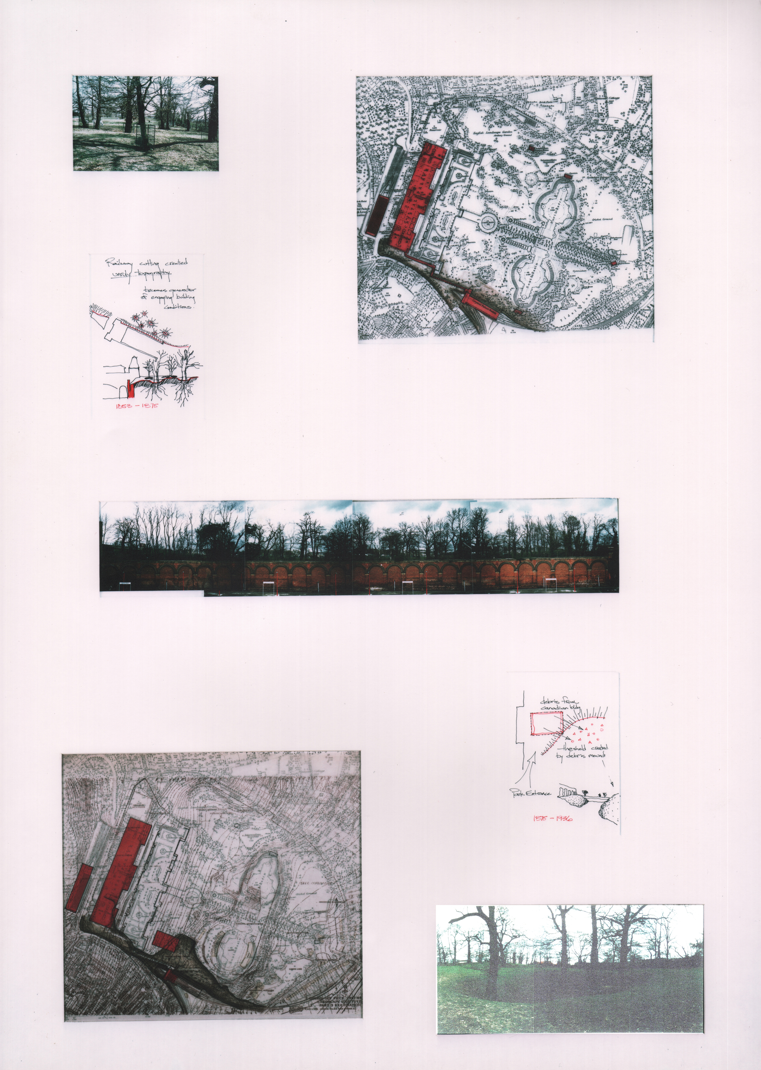
In the photo of the retaining wall (right) constructed to retain park soil that was excavated away from the rail line is an example of edge definition, creation of open space and defining the edge between the community and the park. This wall, which formed a covered space for passenger platforms is all that remains of the Crystal Palace Low Level Station's train shed. This space is the subject of one institutional occupation, namely, The British Rail Museum. While this institution is not the subject of this proposal, the greater goal of creating an institutional edge between the community and the park is material to this aspect of revitalizing the park as a method of revitalization and reinforcement of the strong park edge- a place where community and institution celebrate the park without contaminating it with more freestanding clutter.
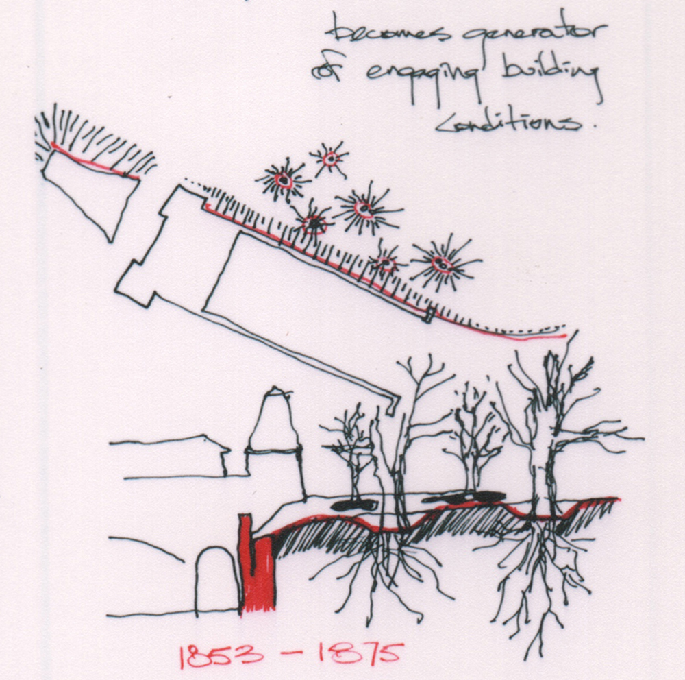
This sectional sketch through the Low Level Station's retaining wall with the park is a common feature of railway cuttings. It just so happens that this condition is such a strong element on this southern edge of the park that other similar retaining walls such as the "Italianate Terraces" and similar conditions at the High Level Station conspire together to dictate rules followed by prior projects. The temporary nature of the Crystal Palace, which was not designed to survive the turn of the century and eventually fell into disrepair provides the converse precedent for what should be free-standing (setting atop the plateaus) and what should be engaging the contours (holding back the chasm).
In the case of the Beekeepers Institute, the siting of this project will follow a similar story to the siting of the Low Level Station by Paxton- The presence of the building should facilitate some aspect of access to the park (in this case also access back down to the Low Level Station Tunnel for rail transport and a Trainspotters Cafe (also not the subject of this proposal). The Beekeeper's Institute will also follow the curious rules of accommodating existing deciduous trees within the deposition grading (creating craters around deciduous tree trunks in order to protect them from placement of new debris).
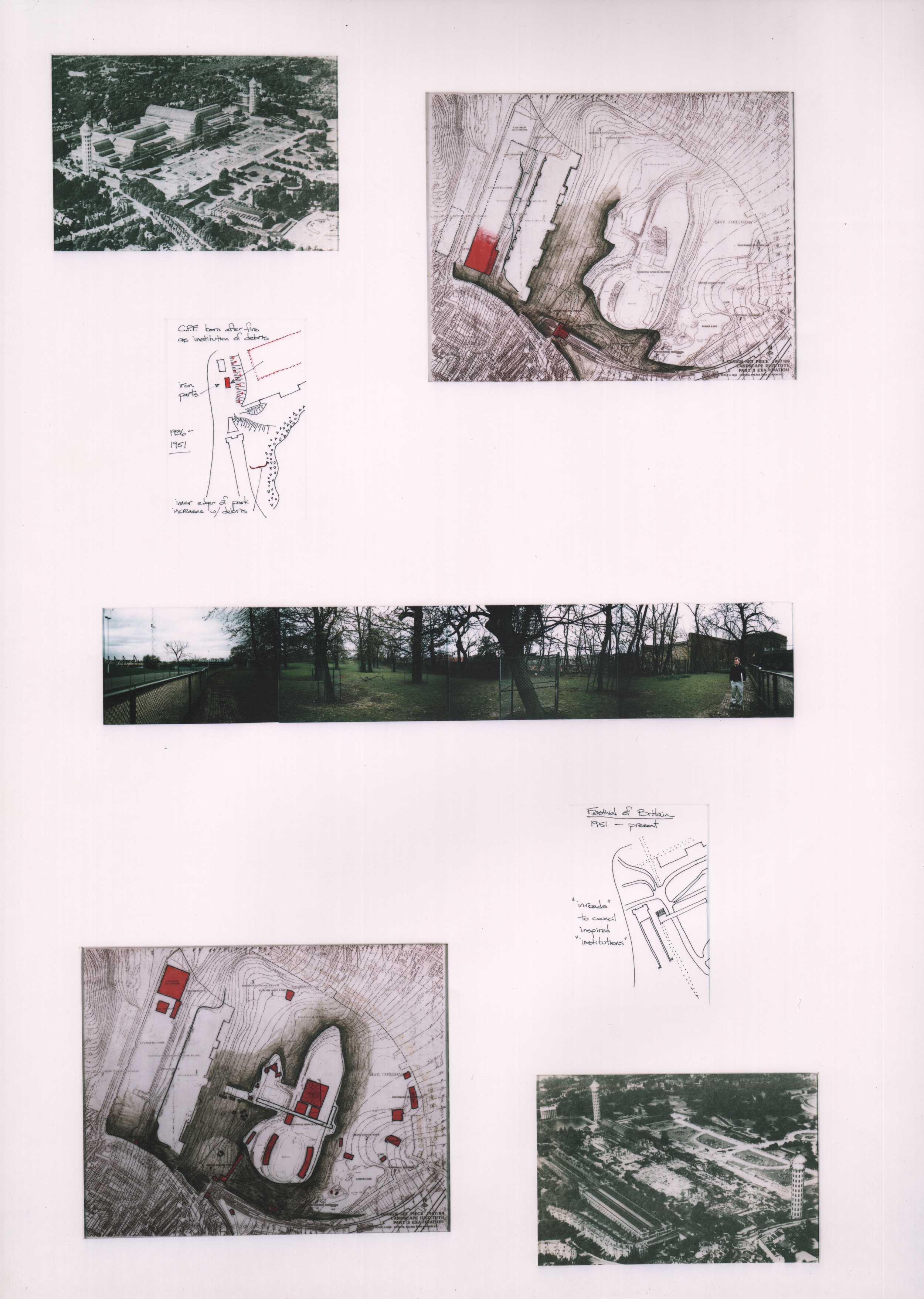
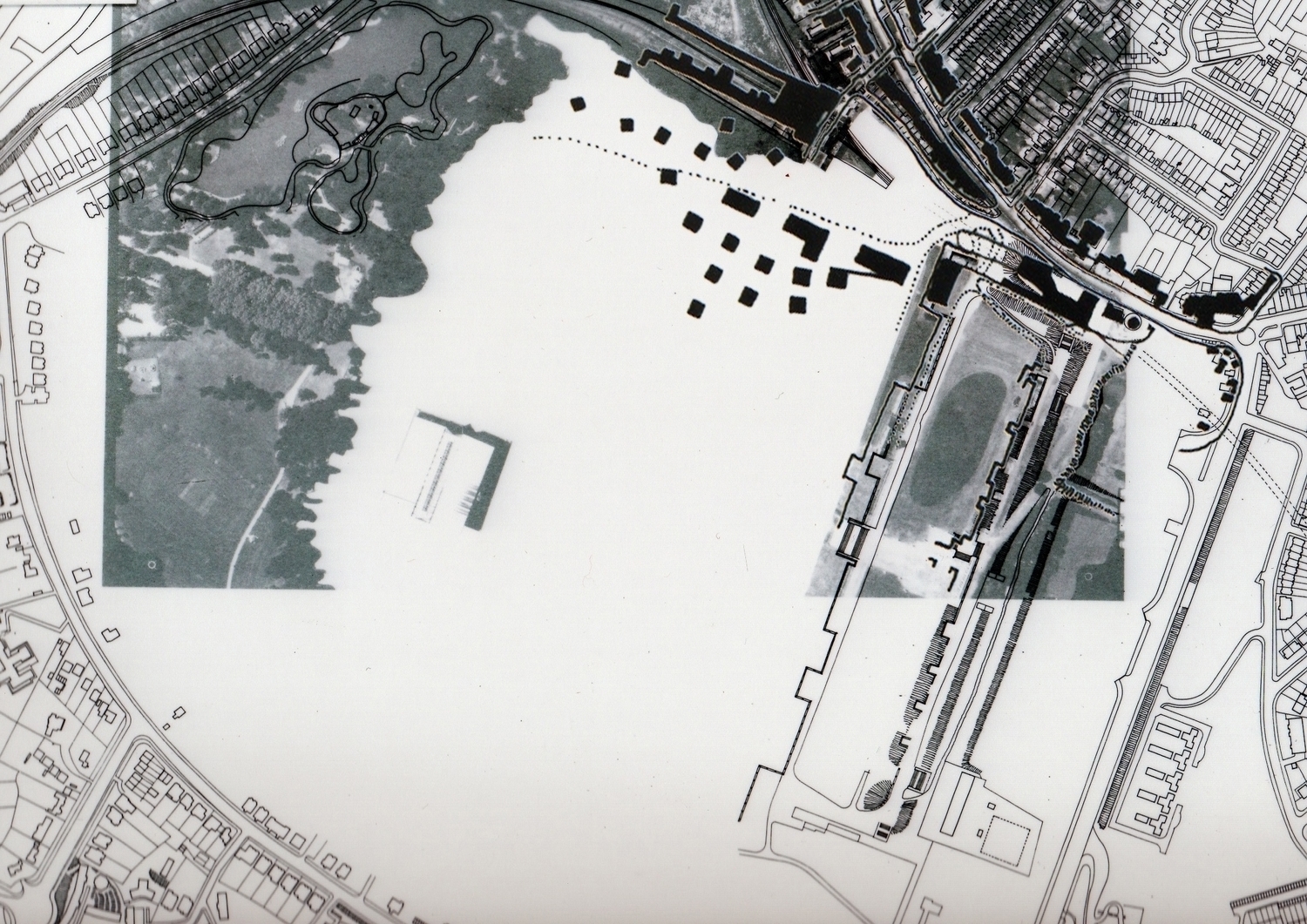
These curious conditions are telling of a possible landscape strategy that could determine tree placement. Since all of the existing trees are deciduous, and grow out of a loamy indigenous soil, they reflect those soil conditions and shall be preserved in a similar manner as the Victorians who moved debris around the park by horse cart and relented from burying tree trunks in backfill. Hence the craters that are visible around Poplar and Tulip Trees that are common to the southern edge of the park. New tree plantings that will be asked to grow in landfill conditions (sandy loam with hardcore and other debris) will reflect those soil conditions and the location of these trees will be determined by a simple fractal that responds to the steepness (more frequent plantings) or the shallowness (less frequent plantings) of the grade in any particular part of the site where topographical change is being driven by deposition of demolition material. After the fire of 1936 that incinerated the Crystal Palace Building, there was hundreds of thousands of tons of broken glass, melted iron, and other non-biodegradable debris that required disposal and burial. The park grounds offered a ready-made dumping ground for this material. The brown shading in the two plans (right) indicate four separate phases of earthwork and landfill operations that occurred over 50 years. By identifying the pattern of repeated demolition deposition, the topography begins to tell a story that bears repeating. By the 1960s, The London County Council took charge of the site and the architects department undertook the task of designing the Crystal Palace Sports Centre. (shown shaded in red, lower right) The local football team plays in the outdoor stadium (scheduled for demolition in this proposal due to structural decay) while the indoor sports facility contains an Olympic Class Swimming Pool and Diving Platforms, indoor racquet sports, basketball courts and many other activities. It should be noted that this building is the only existing building to remain standing in the Crystal Palace Park as a result of this proposal. This is because the architects who designed this building succeeded in creating a destination in the landscape that breaks all of the rules of the park by qualifying as a permanent, freestanding building that has withstood the test of time and is an asset of the community. Other than that, this building is a vintage example of 1960s Brutalism that has won English Heritage Listed Building Status and must not be demolished.
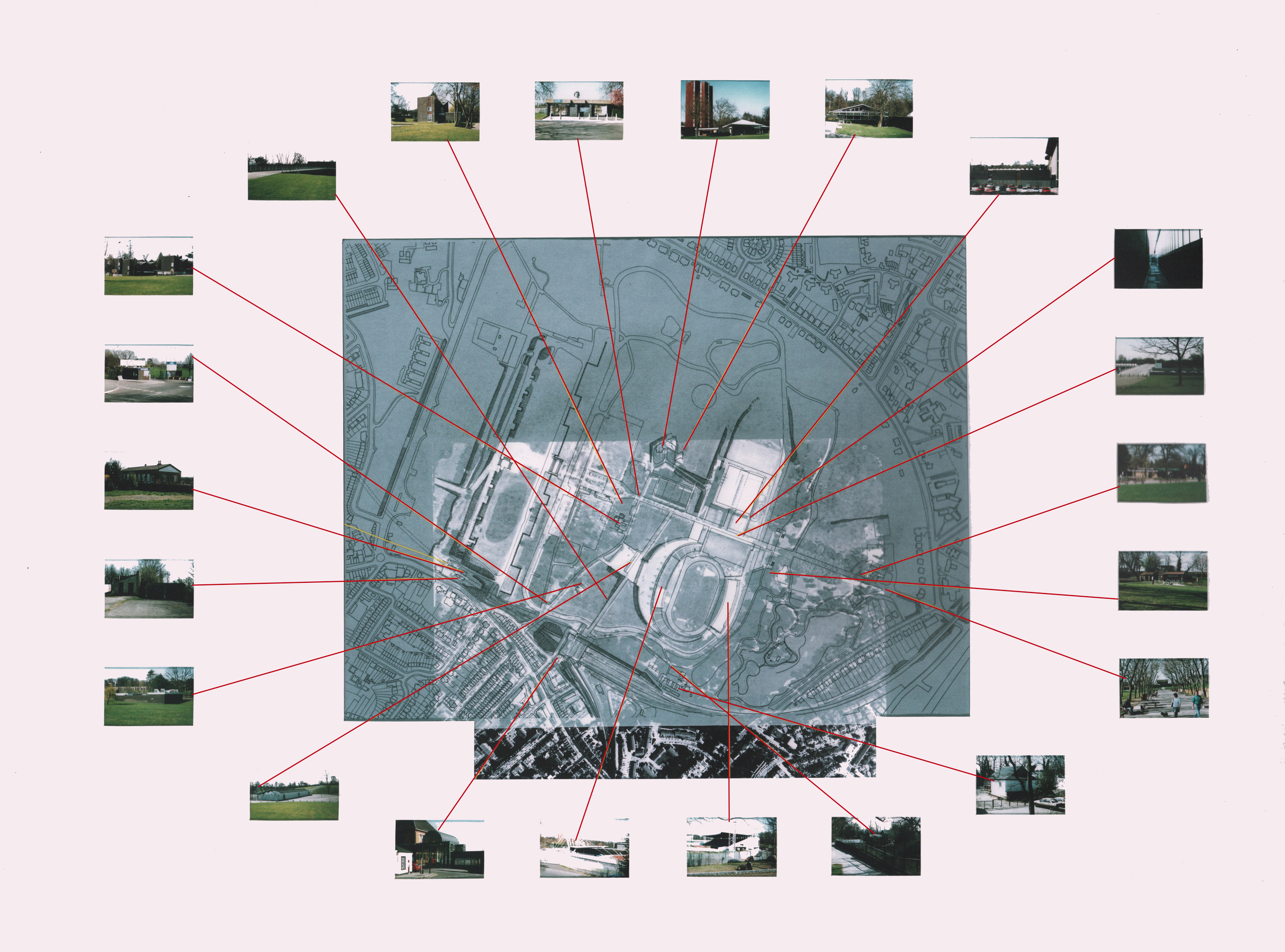
The other 22 buildings that remain standing in the park are scheduled for demolition and are shown on the demolition schedule (right). The debris from demolition of these 22 buildings will be deposited in the park in traditional locations as previously discussed. Identification on the site plan of the dumping grounds is the subject of analysis below.
The buildings shown in this demolition schedule are worthy to be destroyed and their remains should be pulverized into rip-rap of sufficiently small size as to support the growth of Marine Pine root structure. Additionally, the lots vacated by these buildings will be replaced by tree plantings suitable to the soil type and located according to the fractal generated forestation plan discussed below.
Once the site is clear of appurtenances listed above, the 50 acres of clearing leaves only the previously existing trees and the Crystal Palace Sports Centre remaining on the site. The opportunity to reforest the site is secondary to resolving the exact topography that will provide for the disposal of future debris from demolition in such a way as to achieve the previously stated goals of;
a) thresholds to the park are defined
b) opportunities for passers-by to learn about these institutions
c) construction is designed retain the additional landfill
d) fostering the creation of open space
e) defining the edge between the park and the community
Given these goals, the sketches, the process and the unusual opportunity to design a Beekeepers Institute it becomes important to set the stage carefully for an over-riding metaphor to govern the creation of such an eccentric building. Such a metaphor may lie in the accretion that occurs when a swarm of one hundred thousand honey bees take flight and then choose some hollowed-out tree trunk to occupy as the location for their new colony. The topographical preoccupation understood here may draw some allusions to the interior of that tree trunk and the occupation of that void by the bees.
In exploring the southern boundary of the park, there falls upon the landscape a limit beyond which the streetscape of the community, with it's pavement, roads, curbstones, buildings and signposts give way to the softer textures of the park with it's gravel walkways, grasses, undulating ground and retaining structures. This limit is also informed by the grand space created by the Crystal Palace Low Level Station West Facade. There is also a gaping crater in front of the Low Level Station which is the entrance to the Sydenham Hill Rail Tunnel.
By determining a hard edge to the park, the deposition of debris resulting from demolition of the 22 buildings scheduled for destruction can be dumped up against a retaining wall of core-ten steel sheet pile that contains the debris effectively drawing strength from it and rises above it and becomes perforated by selective oxyacetylene cutting to reveal an evocative motif of marine pines that come to life just beyond.
The Marine Pine thrives in sand. Deciduous Trees thrive in loam. It's that simple. Where deposition of debris has occurred, sand will cover the debris in order to bury it sufficiently below the surface. There you will see Marine pines planted almost exclusively. In some areas you will see both species, Deciduous and Coniferous. Currently there are few, if any Coniferous trees. These Coniferous Marine Pines will grow in such a way as to restrict their foliage to an upper canopy, like a Palm Tree, leaving the lower half of the trunk barren of foliage. Such a species of tree is ideal for walking through a forest of tree trunks, unhindered by low level foliage and affording the forest forager views through the trees to the background topography and buildings in the distance.
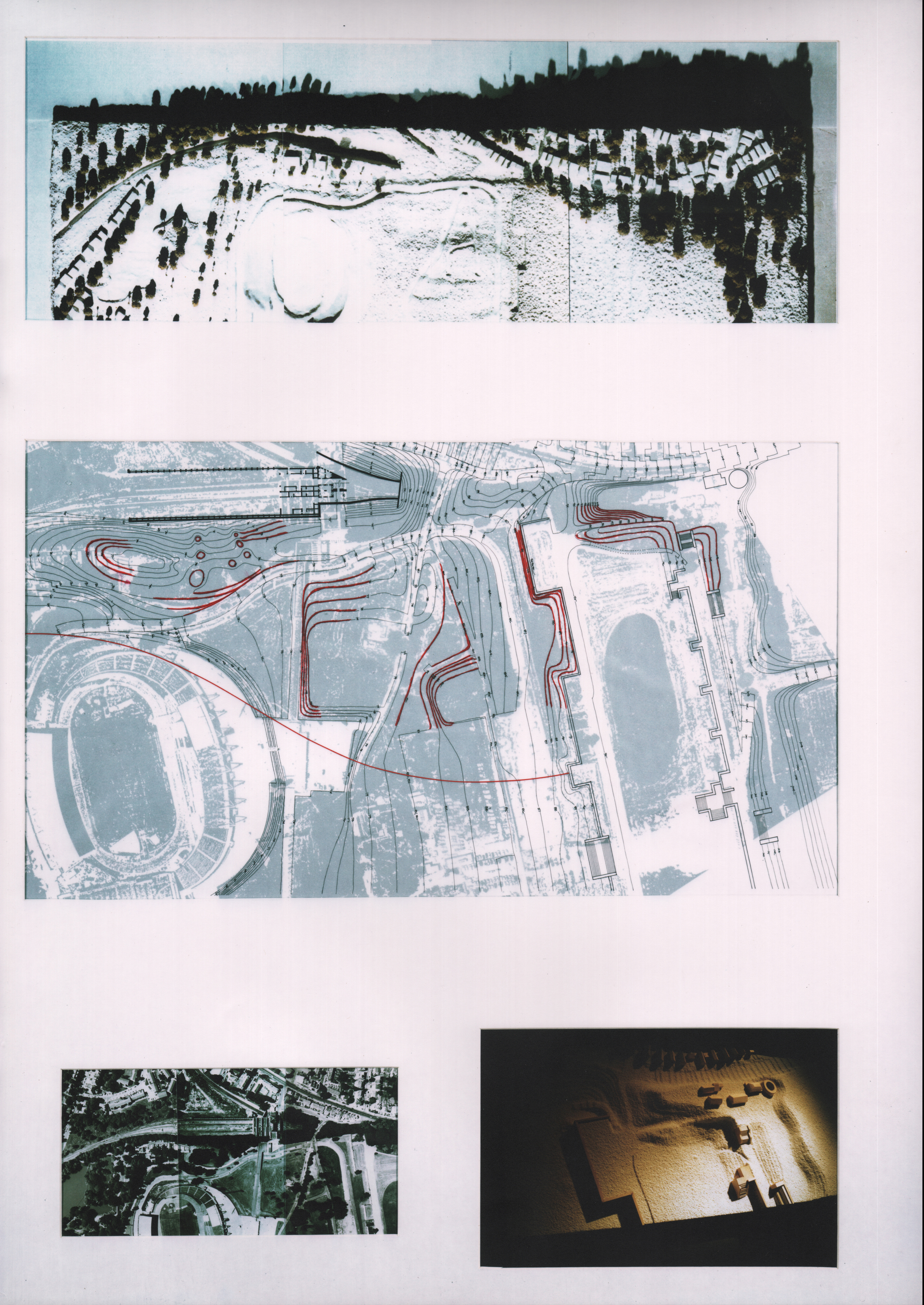
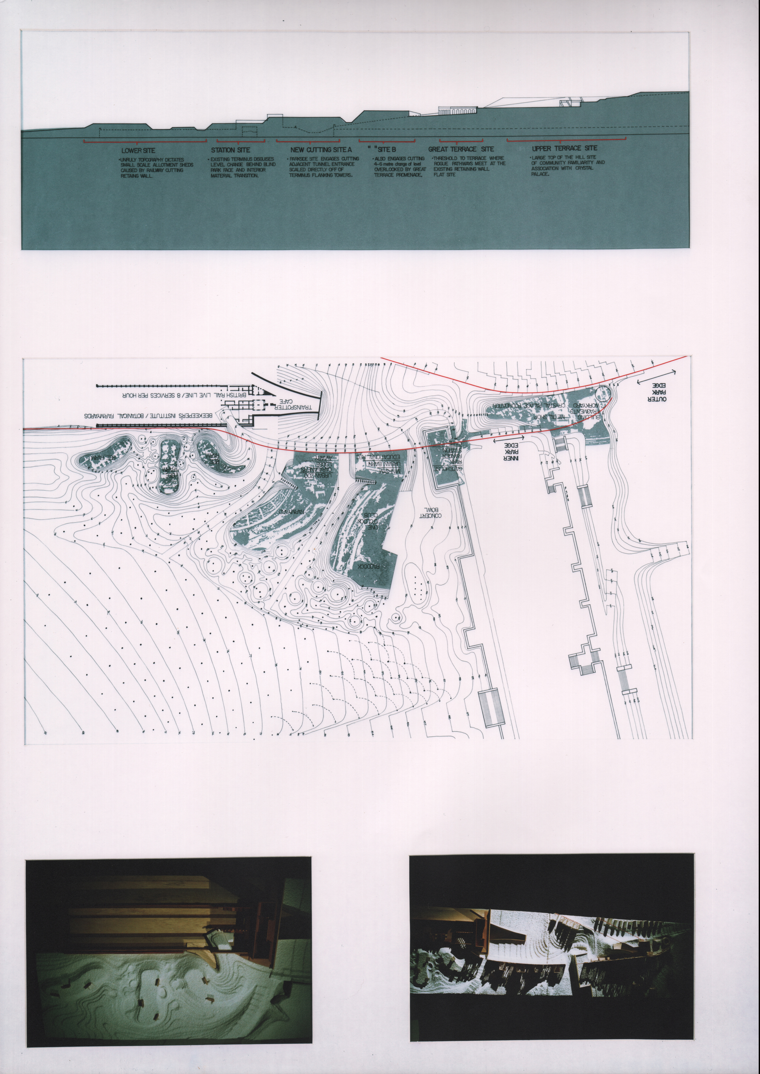
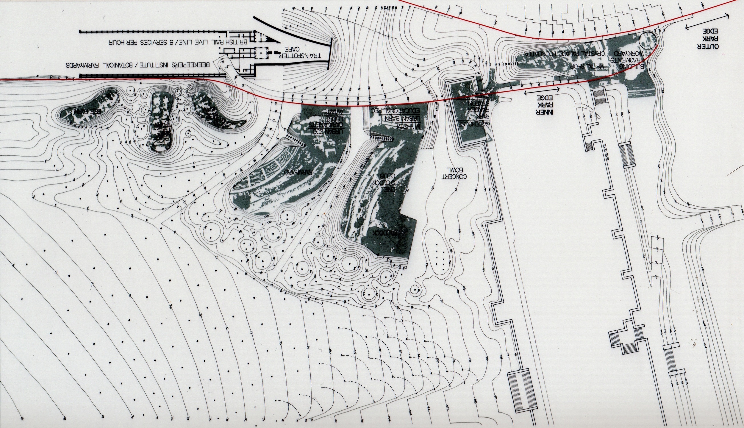
In addition to setting a limit to the park topography with a hard edge, an additional limit, represented by the lowest red line in the plan (lower right) which defines the extent of the "dumping" or deposition of debris from demolition. This edge would be visible in the landscape as the edge of the Marine Pine Forest which grows in the sandy substrate and escalates in planting frequency and slope as the landfill slopes up to the plateaus. Beyond this red line, the newly landscaped park would be replanted with indigenous deciduous Tulip Trees, Chesnut Trees and Oak Trees in addition to the existing trees.
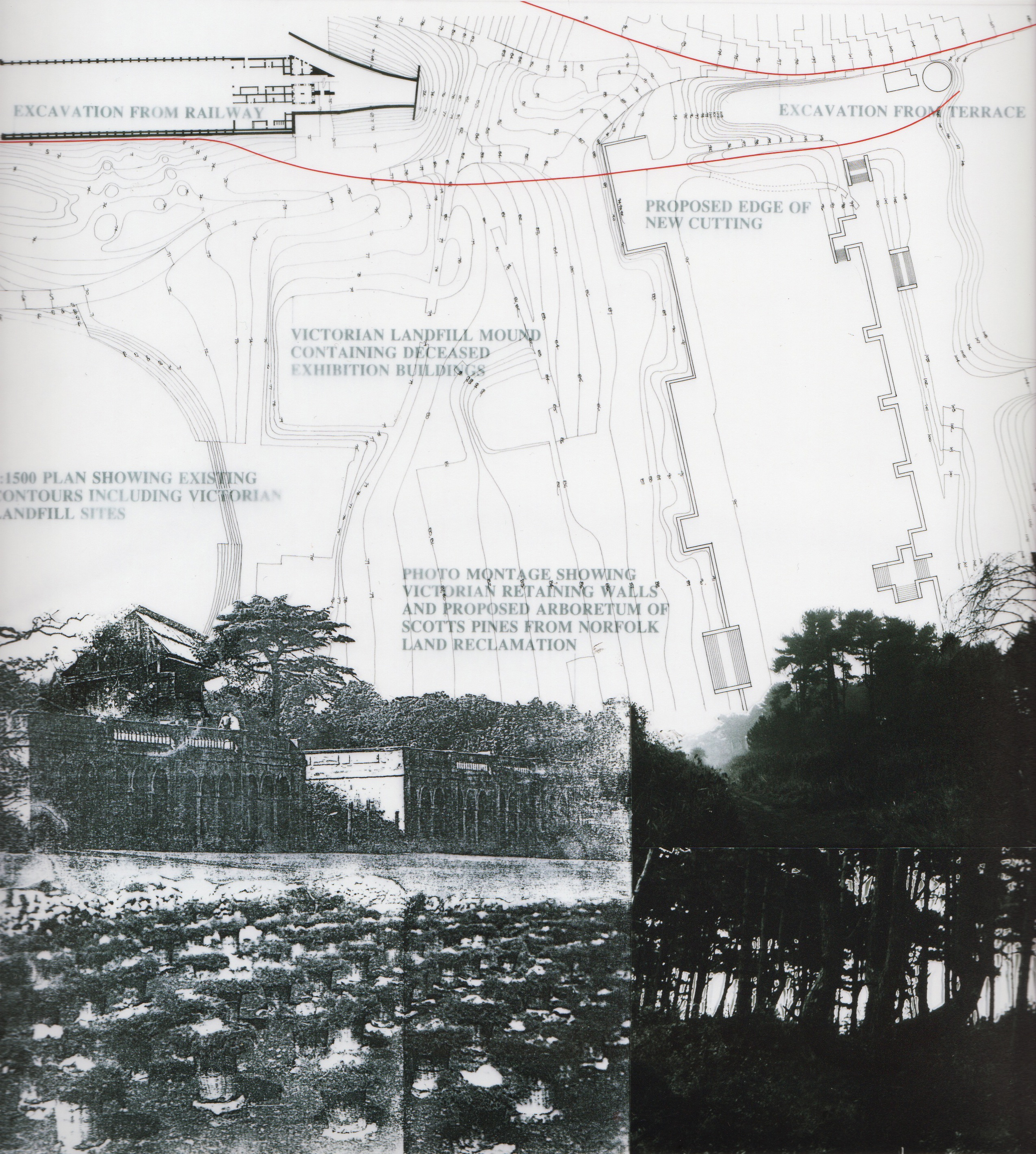
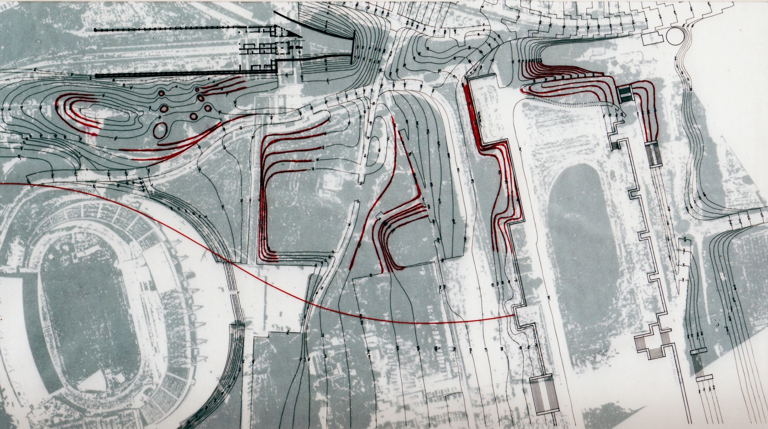
The red contour lines in the plan highlight the existing contours that are caused by "dumping" by previous deposition of debris and therefore define a precedent location for current "dumping" or deposition of debris from the current proposal to demolish the 22 buildings scheduled to be buried above. By comparing the existing and proposed contour plans (based on 25,200 cubic yards of demolition debris) one can see the evolution of the proposed landforms compared to the current grade.
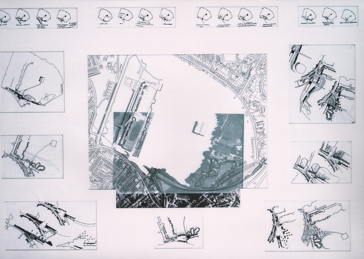
The addition of more landfill to these existing mounds from the Victorian Era is an exercise that has attracted a great deal of attention to the proposed grading plan by constructing 1:500 scale topographical models, These models, themselves the result of contour sketch investigations, are then transposed into larger scale topographical models as will be shown below. The objective of these studies is to evolve the proposed site plan as carefully as the development of the geometry of the building that will be accommodated using the rules described above.
The plateaus (shown in the site section to the right) step down with the slope of the park and rise to a height above the existing grade that will provide views across the park landscape. From atop these plateaus, it will also be possible to comprehend activities on the downhill plateaus. The activities that occur on each of these will not, as discussed above, involve the construction of any permanent structures.
In plan, these plateau shapes are the result of careful building up of the contours from lower levels that have public footpaths predetermining the shape of the base. Therefore, the plan shapes are further registration of movement systems between the park and the community that survive the very same debris that once formed buildings in the park that these paths delivered visitors to.
The Low Level Station also has retained a very large amount of earth moving that was the result of the original 1860s railway cut. Additional debris deposition can be observed in this area immediately adjoining the train shed wall shown in the photo above. The proposal shows additional plateaus adjacent to this wall that have received some of the additional demolition landfill of the 22 building schedule above. These plateaus provide the opportunity for foot travel from inside the rail station, over the 150 year old brick retaining wall and into the park using the plateaus as a stepping stone. These transitions are not the subject of this project.
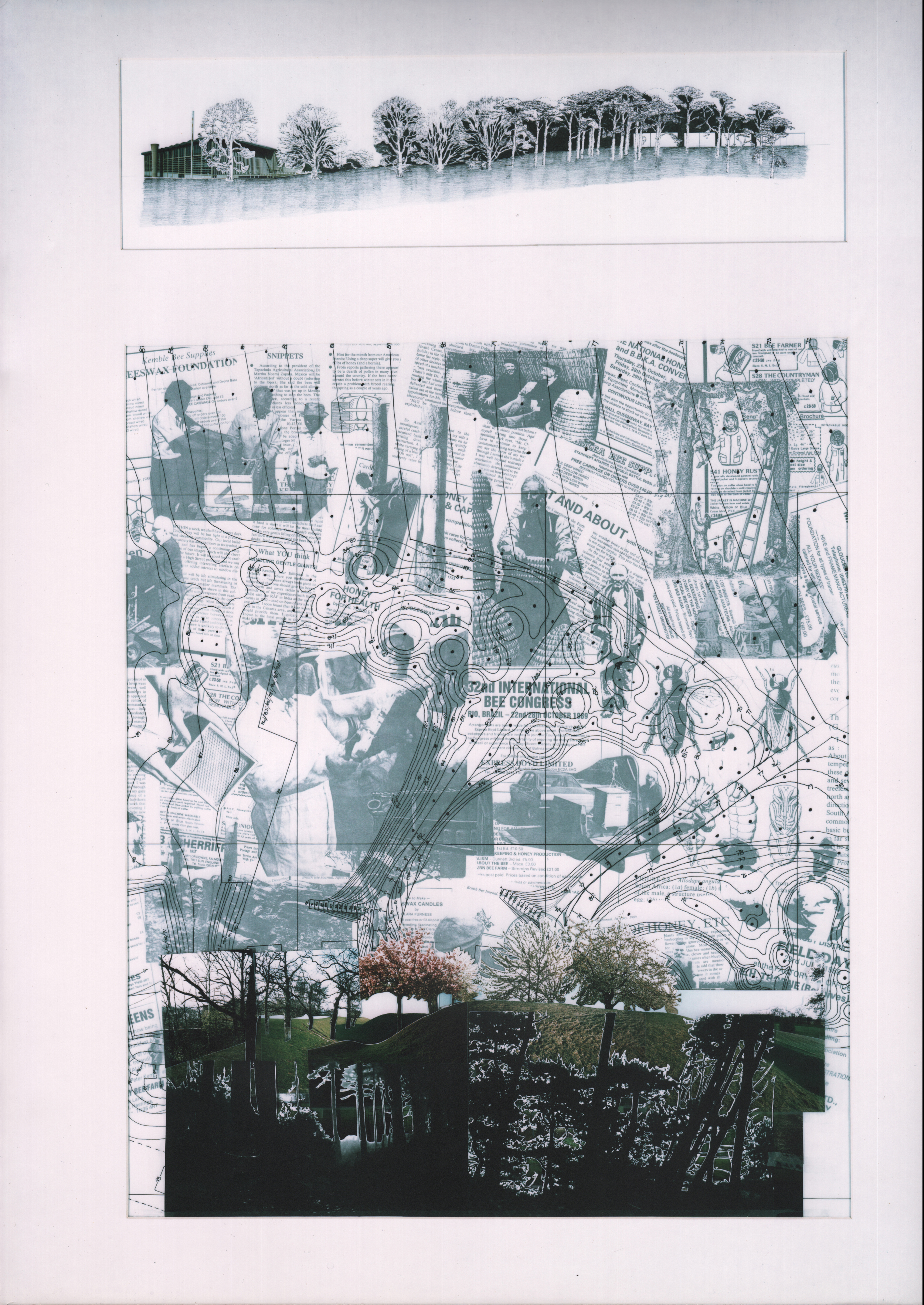
The existing deciduous trees are visible in the soil unaffected by the landfill activities. The Marine Pines become prevalent in the affected soil. This soil also happens to be the most unruly topography (steep and crater laden), The sketch (right) is illustrative of the intent to landscape the edges of the plateaus with Marine Pines which have the benefit of providing views through their tree trunks, through to the tops of the plateaus and the activities that take place there. This curious place at the top of the plateau in the coniferous trees is the desired affect that this place should have upon foot travelers that pass by on public footpaths.
The Sports Centre (the only building in the park that is preserved from demolition) is visible in the left side of the drawing, on the downhill slope. This region of the park is exclusively landscaped with indigenous deciduous trees and the Sports Centre, which is obscured by the Deciduous Trees at the base, is easily visible above the trees, largely due to the enormous scale of the Sports Centre. Hence the converse landscape goals of plantings around the park and plantings around the institutional buildings are opposed to each other and differentiate their respective territories.
The collage (right) superimposes the activity of Beekeeping onto the planting layout and contour plan with jumbled cutout photos of Marine Pines and Cherry Trees (special activity-related plantings for the Bees pollination and nectar forage). This hodge-podge of seemingly unrelated items come together in this collage to communicate a cross-fertilization between the bees, the landscape and the topography.
Once the land masses had taken form, the plateaus defined and the movement systems, thresholds and boundary with the community were established, the building rules simply had to be followed and the enjoyable process of populating the edges of the plateaus with retaining construction- and the spaces that would be formed by them had begun. The program for the Beekeepers Institute contained approximately 15 different major spaces of varying size and public/ semi public/ private nature to each space.
Briefly, the program is descriptive of a working institution that manufactures, educates, archives genetic material, imagery, literature etc. and provides hermitages for individual bee masters to occupy during the flying season. There is also a retail component to the Institution that attracts members of the public to purchase bee products, books, apiary supplies and clothing. There are woodworking shops that manufacture the wooden parts to the various bee hives and other components of beekeeping practice.
The spaces range in size from the largest- a lecture/ exhibition hall which seats over 1000 people and contains 300square meters of exhibition space with a restaurant, kitchen, sanitary facilities and internet cafe...to the smallest- a bee master's studio that is only 20 square meters, contains a table and chair, a small food preparation area and a sleeping area. All of the volumes that make up the entire program consist of the following;
1. Exhibition Hall
2. Lecture Hall
3. Members Room
4. Restaurant, Kitchen, Dining, Toilets
5. Internet Cafe
6. Retail Shop
7. Wood Products Manufacturing Area
8. Hermetically Sealled Honey Extraction, Ripening and Bottling Factory
9. Hive Assembly Area & Inventory Storage
10. Library and Slide Library
11. Locker Room w/ Showers (M&F)
12. Bee Masters Hermitages
13. Live Bee Class "Rooms"
14. Tool Shop
15. Emergency Response/ First Aid
Close-up of Existing Grade/ Park Threshold/ Movement In & Out;
(Re-Iteration)
"In exploring the southern boundary of the park, there falls upon the landscape a limit beyond which the streetscape of the community, with it's pavement, roads, curbstones, buildings and signposts give way to the softer textures of the park with it's gravel walkways, grasses, undulating ground and retaining structures. This limit is also informed by the grand space created by the Crystal Palace Low Level Station West Facade. There is also a gaping crater in front of the Low Level Station which is the entrance to the Sydenham Hill Rail Tunnel. By determining a hard edge to the park, the deposition of debris resulting from demolition of the 22 buildings scheduled for destruction can be dumped up against a retaining wall of core-ten steel sheet pile that contains the debris effectively drawing strength from it and rises above it and becomes perforated by selective oxyacetylene cutting to reveal an evocative motif of marine pines that come to life just beyond."
Close-up of Landscape Strategy;
(Re-Iteration)
"These curious conditions are telling of a possible landscape strategy that could determine tree placement. Since all of the existing trees are deciduous, and grow out of a loamy indigenous soil, they reflect those soil conditions and shall be preserved in a similar manner as the Victorians who moved debris around the park by horse cart and relented from burying tree trunks in backfill. Hence the craters that are visible around Poplar and Tulip Trees that are common to the southern edge of the park. New tree plantings that will be asked to grow in landfill conditions (sandy loam with hardcore and other debris) will reflect those soil conditions and the location of these trees will be determined by a simple fractal that responds to the steepness (more frequent plantings) or the shallowness (less frequent plantings) of the grade in any particular part of the site where topographical change is being driven by deposition of demolition material. After the fire of 1936 that incinerated the Crystal Palace Building, there was hundreds of thousands of tons of broken glass, melted iron, and other non-biodegradable debris that required disposal and burial. The park grounds offered a ready-made dumping ground for this material."
Close-up of Grading Strategy-
(Re-Iteration)
"The plateaus (shown in the site section to the right) step down with the slope of the park and rise to a height above the existing grade that will provide views across the park landscape. From atop these plateaus, it will also be possible to comprehend activities on the downhill plateaus. The activities that occur on each of these will not, as discussed above, involve the construction of any permanent structures. In plan, these plateau shapes are the result of careful building up of the contours from lower levels that have public footpaths predetermining the shape of the base. Therefore, the plan shapes are further registration of movement systems between the park and the community that survive the very same debris that once formed buildings in the park that these paths delivered visitors to."
Close-up of Massing Strategy-
(Re-Iteration)
"Once the land masses had taken form, the plateaus defined and the movement systems, thresholds and boundary with the community were established, the building rules simply had to be followed and the enjoyable process of populating the edges of the plateaus with retaining construction- and the spaces that would be formed by them had begun. The program for the Beekeepers Institute contained approximately 15 different major spaces of varying size and public/ semi public/ private nature to each space."
The Public Spaces are located at the southern-most end of the Institute at the edge with the community and the most private spaces are located at the northern-most end of the institute (in the park). This gradual transition from public to private occurs over the entire length of the institute which is a series of indoor, indoor/outdoor, outdoor, and indoor spaces that present themselves along a linear path that starts at the top of the uphill plateau and descends downwards to the toe of the slope (into the park) at the end of the down hill plateau.
Close-up of Planting Strategy- (Re-Iteration)
"The existing deciduous trees are visible in the soil unaffected by the landfill activities. The Marine Pines become prevalent in the affected soil. This soil also happens to be the most unruly topography (steep and crater laden), The sketch (right) is illustrative of the intent to landscape the edges of the plateaus with Marine Pines which have the benefit of providing views through their tree trunks, through to the tops of the plateaus and the activities that take place there. This curious place at the top of the plateau in the coniferous trees is the desired affect that this place should have upon foot travelers that pass by on public footpaths."
Series of Sketches exploring the placement of building mass along the community edge;
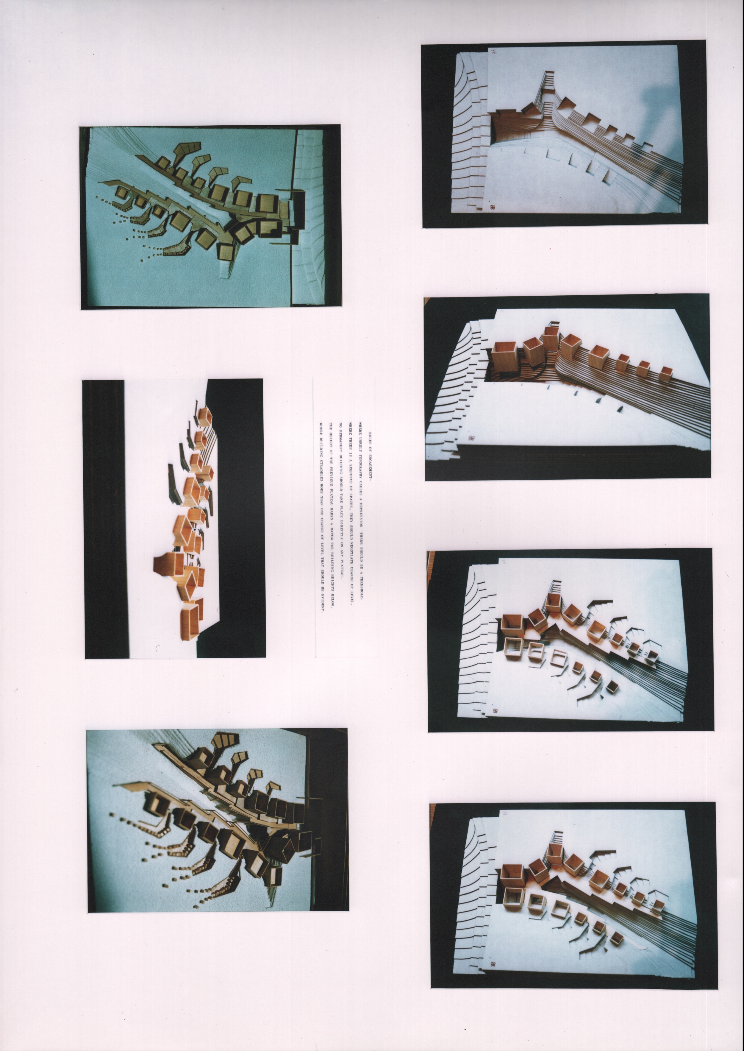
As can be shown in the sketches to the right, the community edge (the long east west wall that retains the landfill) is engaged by separate building masses along it's length. This approach was aborted after several other sketch studies included the landfill masses (the plateaus) and used the chasm between these plateaus as a linear progression instead of the retaining wall.
Progress Sketch:
Once the sketch began to break up the massing along the edges of the plateau and deployed them for the purpose of slope stabilization, the strategy of rules began to take form and the design unfolded after a series of additional sketches.
Progress Sketch:
The buildings and the topography remained separate studies in early sketches, divorcing the two design elements so that it was difficult to synthesize a coherent strategic diagram. This sketch is one example. By using the satellite photos and topographical plans together with the massing sketches, it was clear what was required to move forward.
Progress Sketch:
This "destination building" is filtered by the access through the Beekeeper's Institute public walkway. What this sketch begins to uncover is the path into the park can be populated by institutional buildings as a threshold. As will be shown below, accurately scaled topographical information would tune up the diagram and lead toward a schematic plan.
The sketch to the right is of a concept that eventually evolved into the final concept. The buildings would follow a progressively public to private series of structures and spaces that one would encounter on the way into the newly landscaped park. These buildings would provide a marketplace of information about bees, their care and living conditions, and their surviv
Progress Sketch:
Prior to informing the building concept plan with the more accurate contours and scale, this sketch radiates the more private buildings out into the park, away from the community edge while the larger more public buildings draw upon the strength and size of the retaining wall that is introduced to hold back the landfill along the same edge.
Progress Sketch:
This was the last of the quick and dirty 1:500 sketched that started the direction of the concept toward more resolved, larger scale models and sketches. As will be shown below, much of the subsequent decision making was developed using models as well as larger scale plans.
Progress Model:
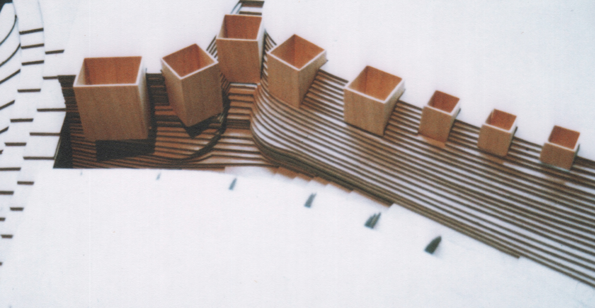
By using the construction to stabilize the slope and retain the landfill, these rectangular boxes also sit inside the landfill mound. This reduces the amount of mass that is presented in elevation to the plateau despite the fact that they are multistory buildings that have relationships with the public space on the top of the plateau as well as a relationship with the interior functions of the institute below.
Progress Sketch:
(Re-Iteration)
"The red contour lines in the plan highlight the existing contours that are caused by "dumping" by previous deposition of debris and therefore define a precedent location for current "dumping" or deposition of debris from the current proposal to demolish the 22 buildings scheduled to be buried above. By comparing the existing and proposed contour plans (based on 25,200 cubic yards of demolition debris) one can see the evolution of the proposed landforms compared to the current grade."
Progress Sketch:
(Re-Iteration)
"The addition of more landfill to these existing mounds from the Victorian Era is an exercise that has attracted a great deal of attention to the proposed grading plan by constructing 1:500 scale topographical models, These models, themselves the result of contour sketch investigations, are then transposed into larger scale topographical models as will be shown below. The objective of these studies is to evolve the proposed site plan as carefully as the development of the geometry of the building that will be accommodated using the rules described above.
Progress Sketch:
(Re-Iteration)
"The plateaus (shown in the site section to the right) step down with the slope of the park and rise to a height above the existing grade that will provide views across the park landscape. From atop these plateaus, it will also be possible to comprehend activities on the downhill plateaus. The activities that occur on each of these will not, as discussed above, involve the construction of any permanent structures."
"In plan, these plateau shapes are the result of careful building up of the contours from lower levels that have public footpaths predetermining the shape of the base. Therefore, the plan shapes are further registration of movement systems between the park and the community that survive the very same debris that once formed buildings in the park that these paths delivered visitors to."
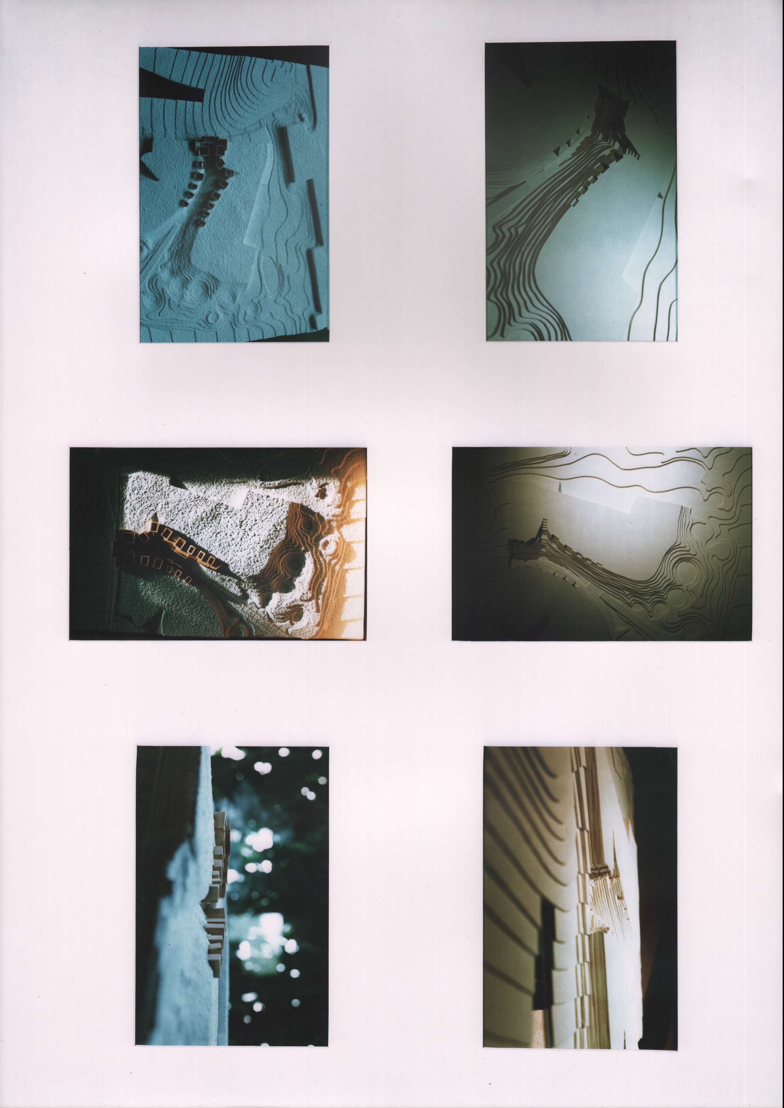
Preliminary Topographical Model:
The settlement of little beekeepers' buildings into the chasm that separates the uphill plateau from the downhill plateau is the opportunity that best demonstrates the previously stated rules of design intent. By excavating retaining walls into the plateau, and incrementally stepping these foundation forms down into the landfill, these allow gaps between the little building forms for further opportunity to echo the same strategy but at a smaller scale. By introducing this gap between the buildings, a new cutting, into the plateau allows for access to the top of the plateau through a stepped farm yard where the beekeepers can stage their bee hives for positioning on the top of the plateau.
Study Model:
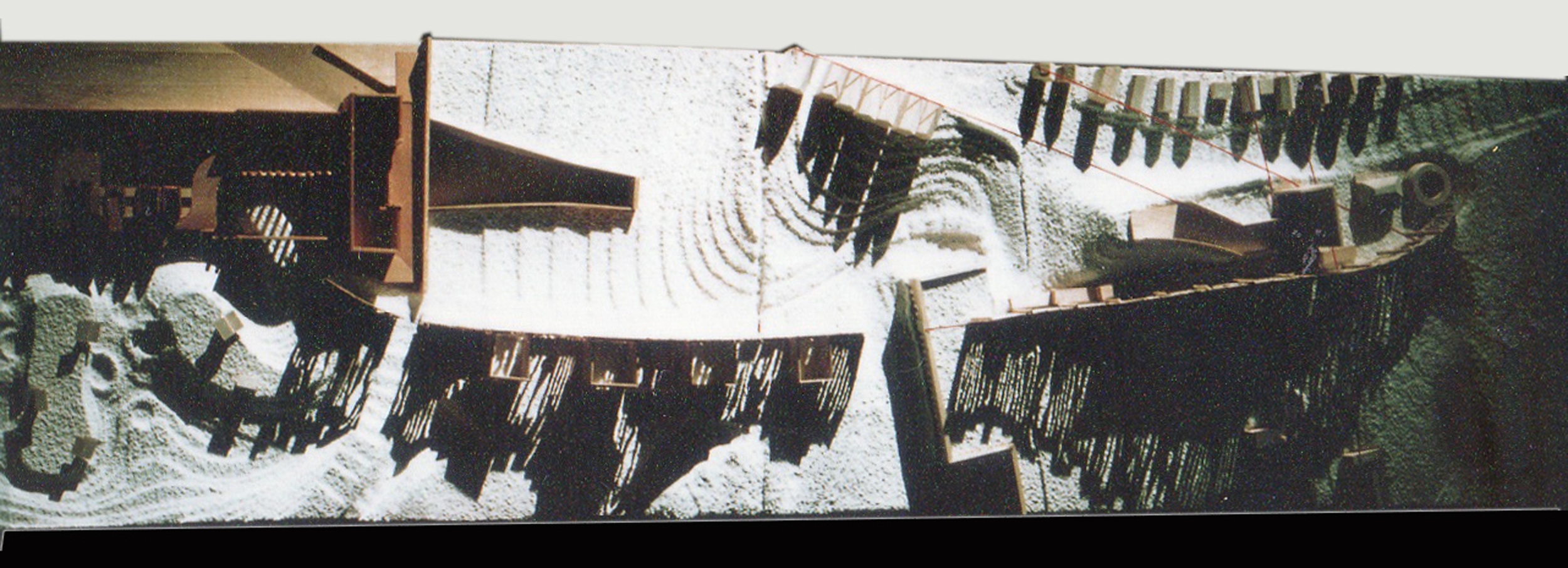
This 1:500 study model followed the sketches above. The extent of the landfill to create each plateau is estimated to be over 22,000 cubic yards (based the on the 22 building schedule of demolition). This model clearly shows the three thresholds into the park that are created by the topography. It also incorporates the community edge as discussed and the rudimentary building volumes are placed along the slope in a progression from public, larger spaces to private, smaller spaces.
Study Model:
Close inspection of this model reveals the introduction of a series of ramps that connect the Bee buildings together on the chasm side of the buildings. This ramp will evolve to become a semi-public footpath that navigates the travel distance from the egress to the park, up to the lecture hall past several BeeMaster Cabins, past the manufacturing buildings and the exhibition hall at the crux of the institute, under the slide library and past the retail store, the bottling plant and past three Bee Masters Cabins and up onto the top of the uphill plateau.
The Chasm-
In the deepest, darkest depths of the topographical depression between the plateaus lies a sloping ramp that leads down into the historical rail tunnel and the Crystal Palace Low Level Rail Station Crypt where, as institutional programming would have it, a Trainspotter's Cafe would exist using space above the tracks that are disused on the north side of the station. This ramp will also provide access to the suburban rail platforms for BeeKeepers commuting into the Institute from Victoria or from Kent. Access to the uphill plateau from the bottom of the chasm directly to the uphill plateau is possible with a transition into and out of the retail shop that sells honey and other bee products and apparel. The plateau is at the top of the stairs and has hundreds of bee hives situated in clusters on the edges of the bee farm.
Farmyard Fractal-
With the introduction of the farm yards between the buildings, a much needed outdoor space for the beekeepers to work with bees, swarms, hive transfers and other activities (that result in congested airspace), the paradigm of using topography to create a threshold space is repeated on a smaller scale within the same project where the site strategy deploys the same concept but at a larger scale.
Model Mock-up-
Prior to building the final model, it was determined that the method of supporting the ramps using treated timber posts was going to be superceded by a new support system that created a retaining wall as the structure and the ramps themselves would sit ontop of landfill. The retaining walls would rise out of the chasm and support the ramps at an angle.
Final Site Model- but still evolves design
The change to the walkway ramps described above, specific changes to the roof structures, and discovery of spaces where articulation of the purpose was enhanced were all additional changes that were incorporated in the final model. As a planning exercise, the landscape, the topography and the building geometry were all significantly improved over the mock-up models. The ability to visualize the building and the spaces was invaluable in fostering the process of planning larger scale planning issues with interactive alterations that delivered a rigorous, yet intuitive project.
Final Model of Bee Master's Cabin and Farmyard-
As discussed above, the paradigm of using topography to create a threshold space is repeated on a smaller scale within the same project where the site strategy deploys the same concept but at a larger scale. This is evident in the Farmyard which represents another topographical feature that is carved out of the mound of landfill whose shape and height are determined by movement systems in and out of the park. In the case of the Farm Yard, the shape and depth of this feature is the result of movement of beekeepers in and out of their Bee Master Cabins.
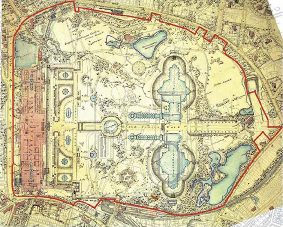
Original Plan of the Sydenham Site (1864)
The path that led from historical colonization of this sub-urban hilltop with a Crystal Palace at the precipice to a Beekeepers Institute nestled in the rubble created by decades of deterioration is simple- The beekeepers have the opportunity to return the site to a landscape of buried artifice and rubble capped by sandy soil mounds. Marine Pines will indicate acreage that has been backfilled with deteriorated historical refuse while deciduous trees populate the remaining unaffected landscape.
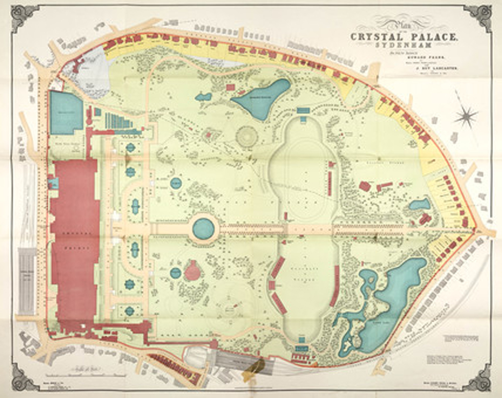
Sydenham Plan As-Built 1911
After the relocation of the palace from Hyde Park in 1864, the grounds saw an accumulation of additional buildings over time. This process of accumulation began after 1911 when the various interest groups in the park started to populate the hillside with buildings that were indiscriminately located. Slowly, the majestic palace's commanding presence over the terraced landscape became subjugated by mediocre brick buildings.
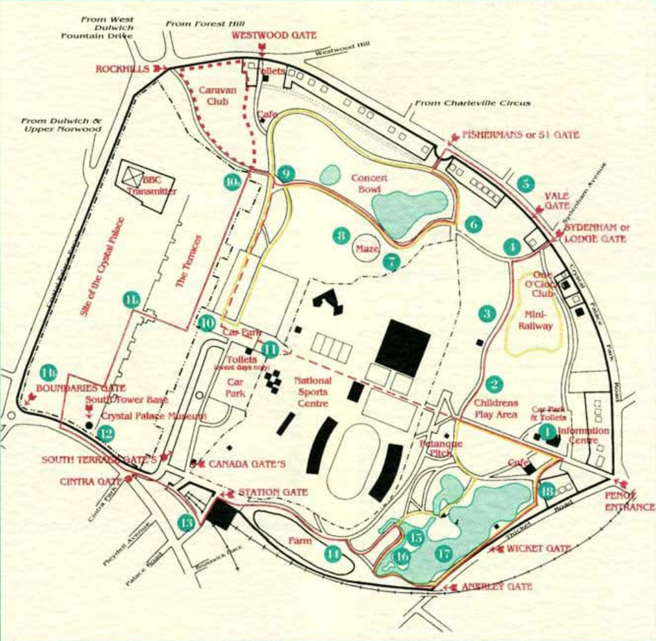
The Crystal Palace Park Today-
Eventually, the Crystal Palace caught fire and burned to the ground in 1936. The debris from the fire was extensive. By this time, many of the auxiliary brick buildings had fallen into disrepair also. And so, nearly fifty years after the extensive grading that fashioned the terraced parkland was started, a second phase of earth moving and debris burial had commenced.
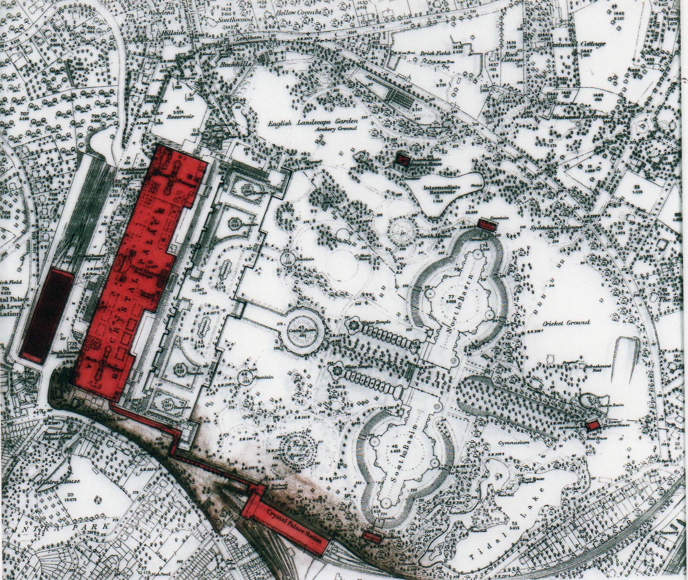
Phase 1 - Crystal Palace in it's Heyday...brown shading indicates deposition of earthwork at inception.
The brown shading on this sketch, and the subsequent series of sketches shows the iterative accumulation of landfill, backfill, and debris over a period of fifty years. The competing interests who wish to recolonize the park after such a long period of deterioration are learning that there is synergy with the unruly topography of yesterday.
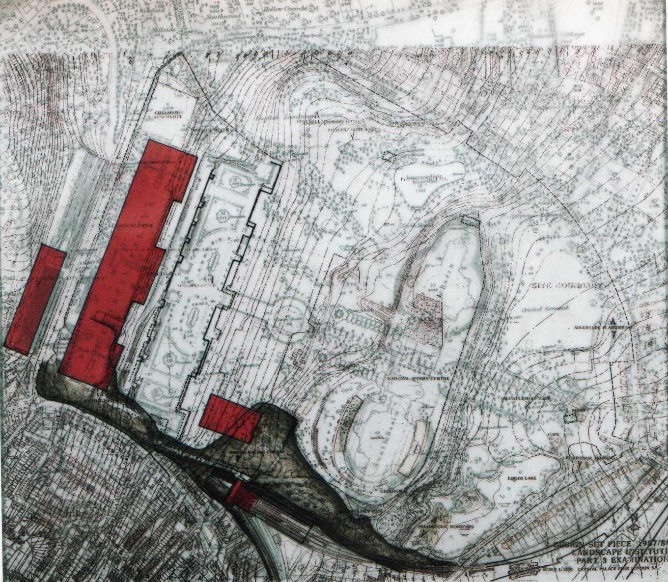
Phase 2 - Crystal Palace begins to deteriorate, brown shading indicates additional deposition of debris.
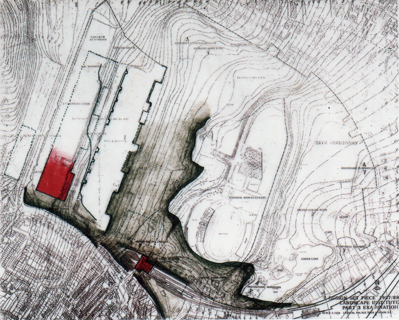
Phase 3 - Crystal Palace burns...in 1936- extensive debris is deposited below terraces and compacted.
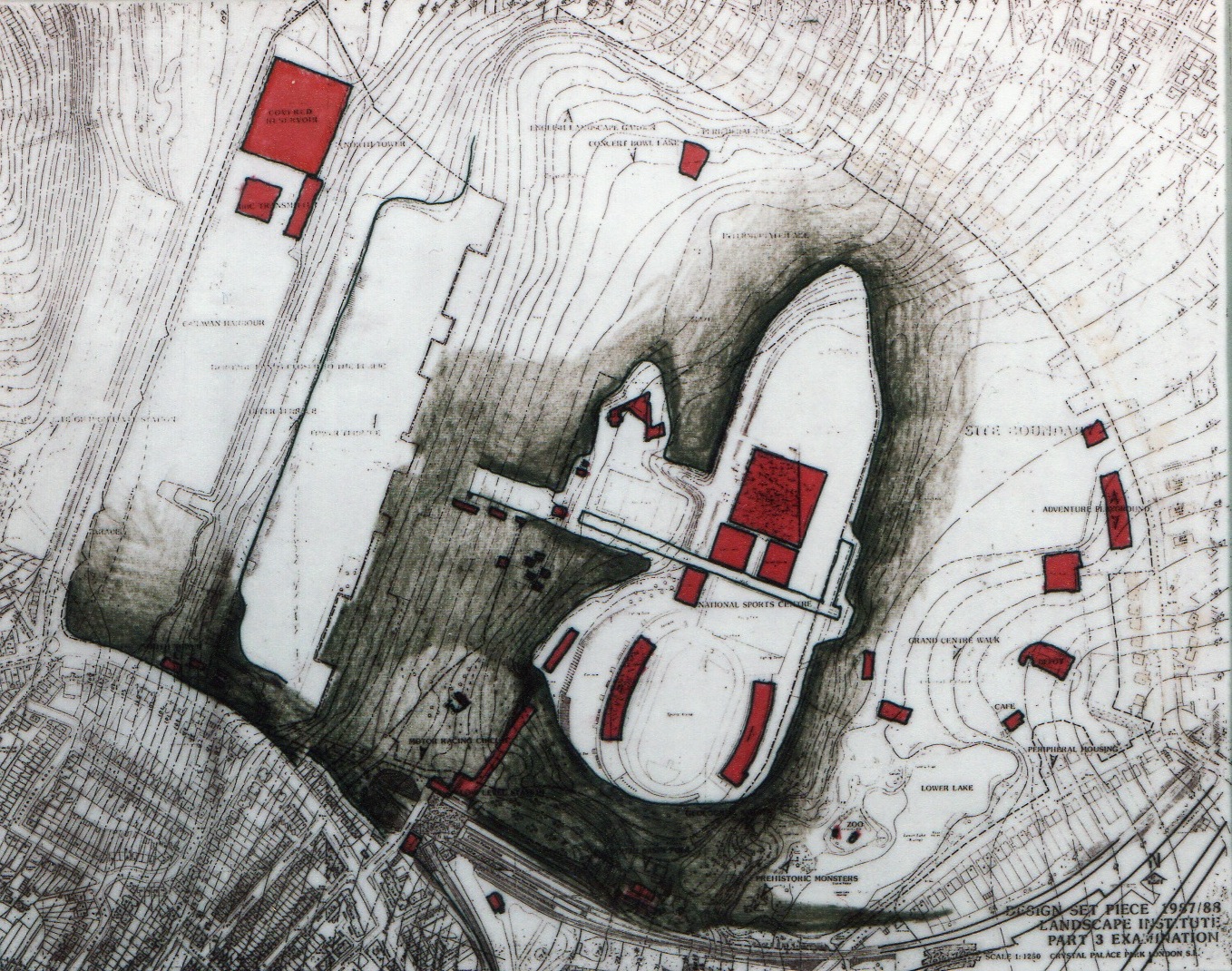
Phase 4 - Decades of debris removal and new grading to allow stadium and sports centre construction.
Deposition of 100 years of debris creates unruly topography- trees grow out of craters of backfill.
History of retaining backfill in order to create space (and a park entrance edge) at Low Level Station is a precedent.
This unruly topography creates gateways and thresholds from the community into the park.
After demolition of legacy buildings, what's left is a single sports destination, new buildings will occupy thresholds.
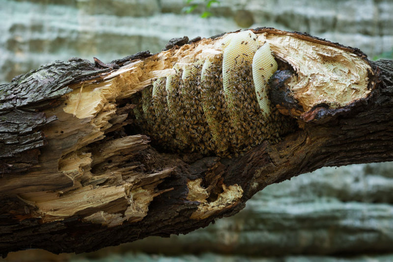
Metaphor for a beekeepers institute in the landscape can be found in a tree trunk.
The land over the top of the railway tunnel gets cleared, the resulting space is an ante space.
These existing landfill mounds will become new, more defined mounds of debris capped with sandy soil.
The new mounds, or plateaus will become spaces for outdoor activities, void of any permanent buildings.
New plantings will indicate landfill- sandy soil by Marine Pines, loamy soil by Deciduous Trees.
The space between the mounds will be occupied by permanent buildings, such as the Beekeepers'.
Sloping down between the plateaus, the grade slopes down to the entrance to the railway tunnel.
The historical debris that is hidden under the green grass of the existing grade makes valleys between the plateaus.
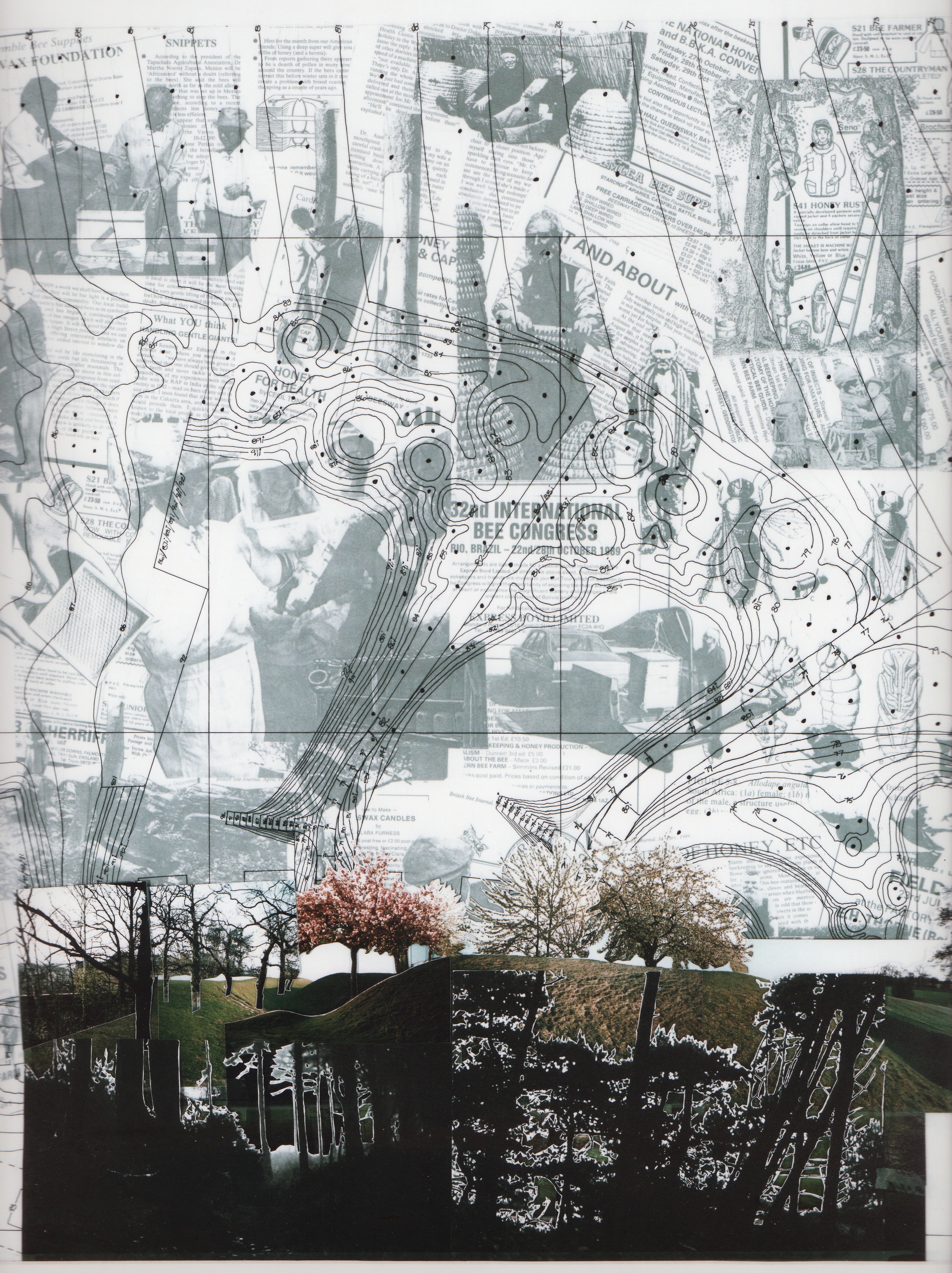
There is a simple formula that determines the location of the new trees- by steepness of topography.

The plateaus step downhill at similar slope to the natural grade, more landfill is required to achieve this.
Sheet pile, driven into the ground retains the southern end of each plateau and becomes enclosure.
The more public spaces in each Institute embrace the sheet pile foil that continues between the plateaus.

Species change from deciduous to Marine Pine as the ground slopes up to more sandy soil on the debris mounds.
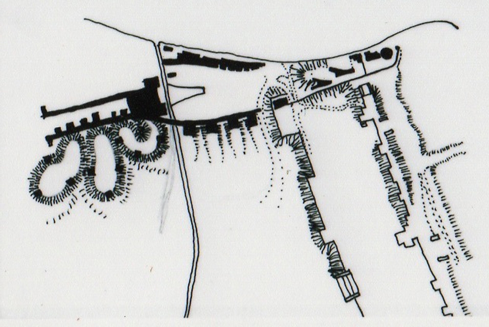
The beekeepers will colonize this section of the "institutional edge" due to the size & publicity of the institution.
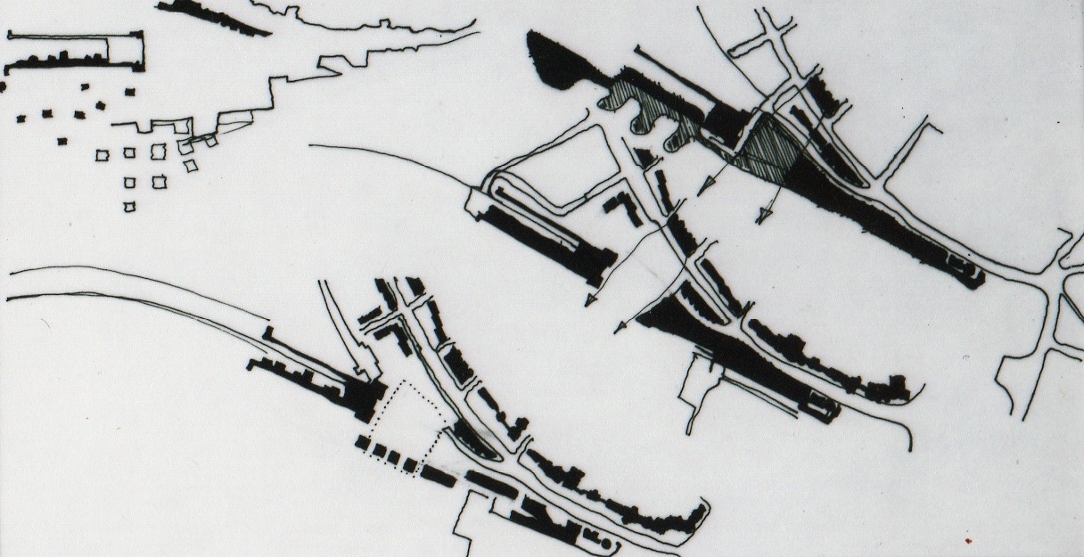
As these sketches explore, the space in front of the rail station is a traditional entrance to park and is now reused.
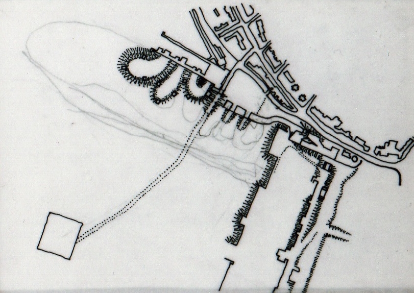
A grade II listed building in the landscape called the Crystal Palace Sports Center is the only remaining building.
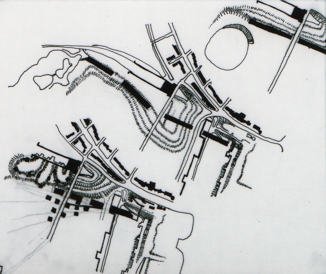
The walkway through the public spaces in the Beekeeper's Institute egresses into the landscaped path to the Centre.
The public footpath which leads through the Beekeeper's Institute will showcase the activities to the public.
Slope stabilization and landfill retention are requirements of each building- none are sited atop the plateau.
Here, the topography defines the pathway to the Sports Centre. Fragments of the original Crystal Palace are buried here.
By depositing the debris from future demolition on historical debris mounds, the topographical space evolves.

A simple fractal determines tree planting locations and frequency according to contour line spacing.
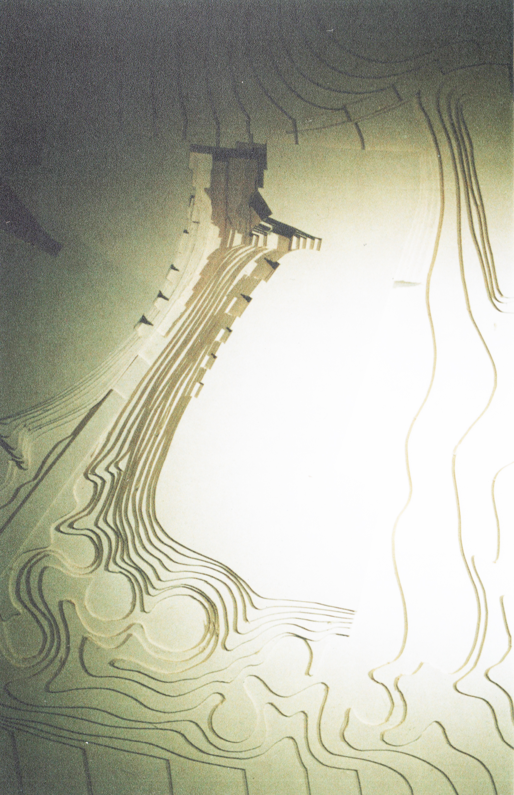
Craters around existing deciduous trees will be created by the new grading scheme which caps the landfill.
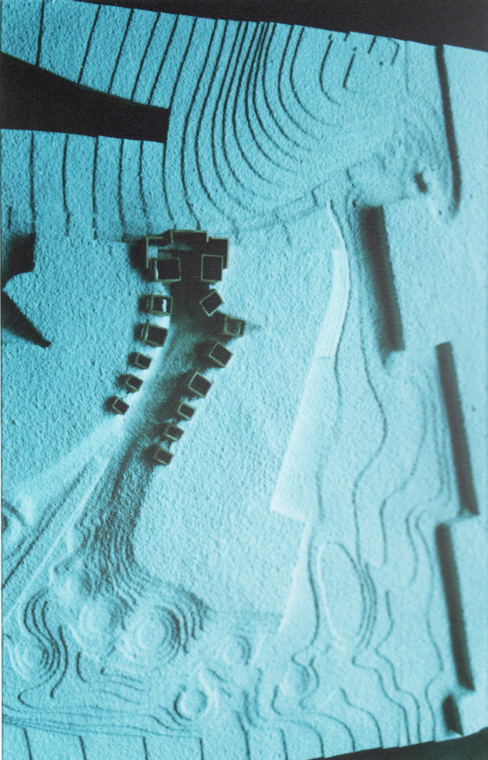
This 1:500 scale model simply illustrates how the buildings "clip" onto the edges of the plateaus and populate the edges.
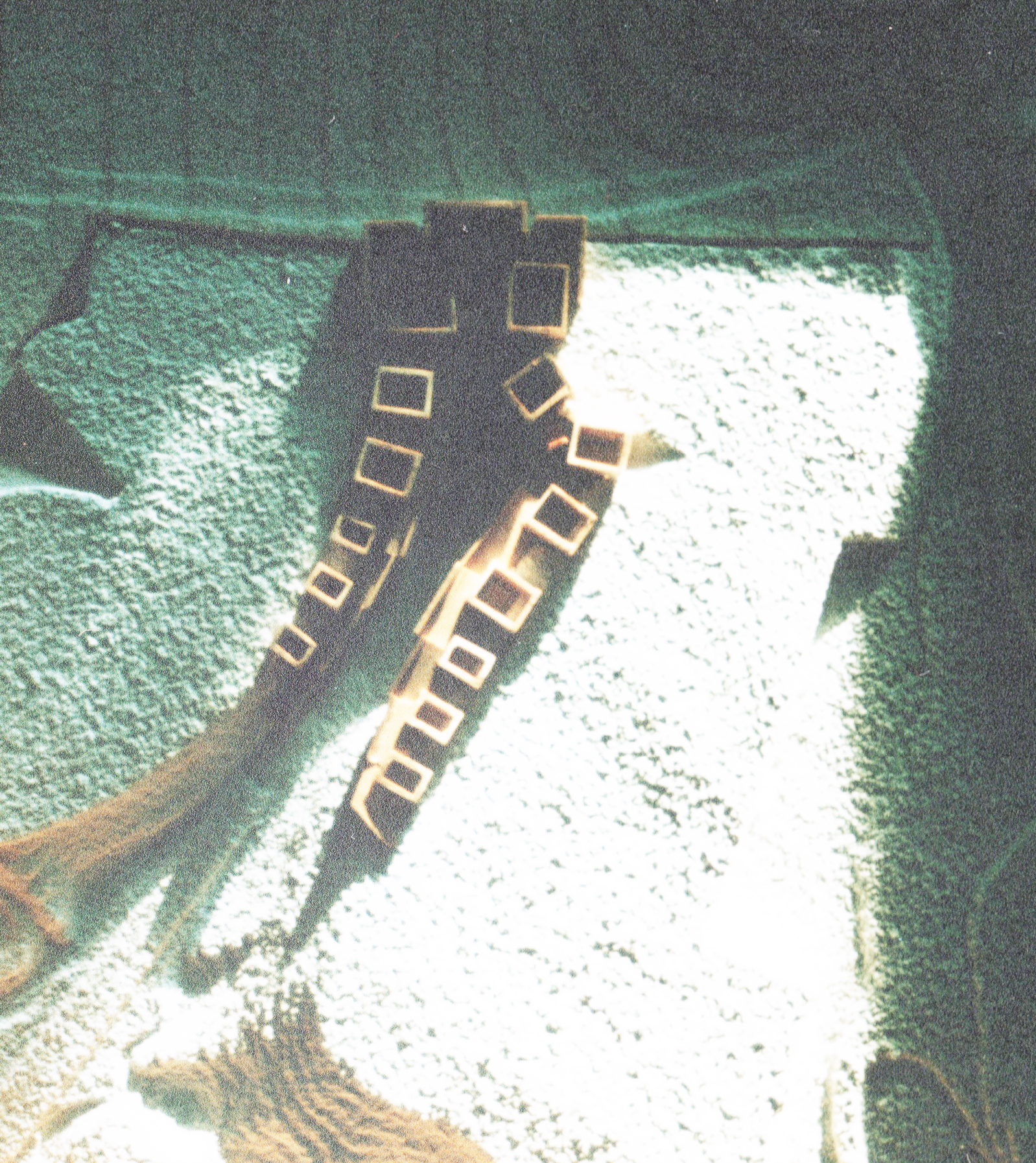
By accreting into the newly formed chasm, the necklace of Beekeeper buildings provide slope stabilization, retention.
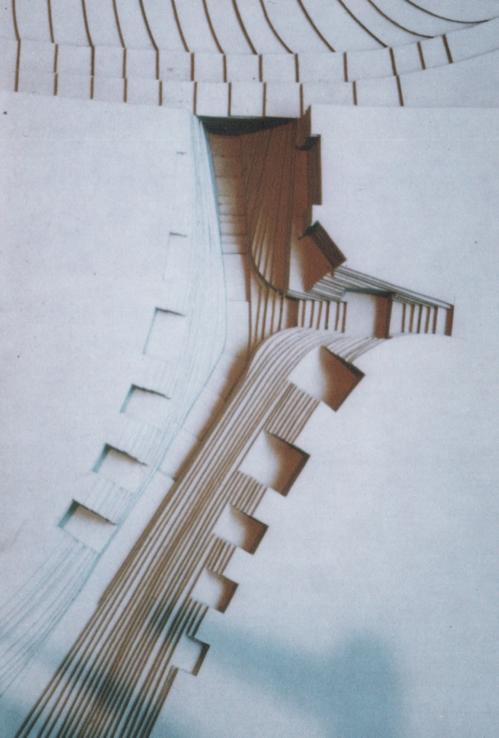
Refinement of the contour planning yields new space, climbs out of the dark rail tunnel and onto the sky fall plateau.
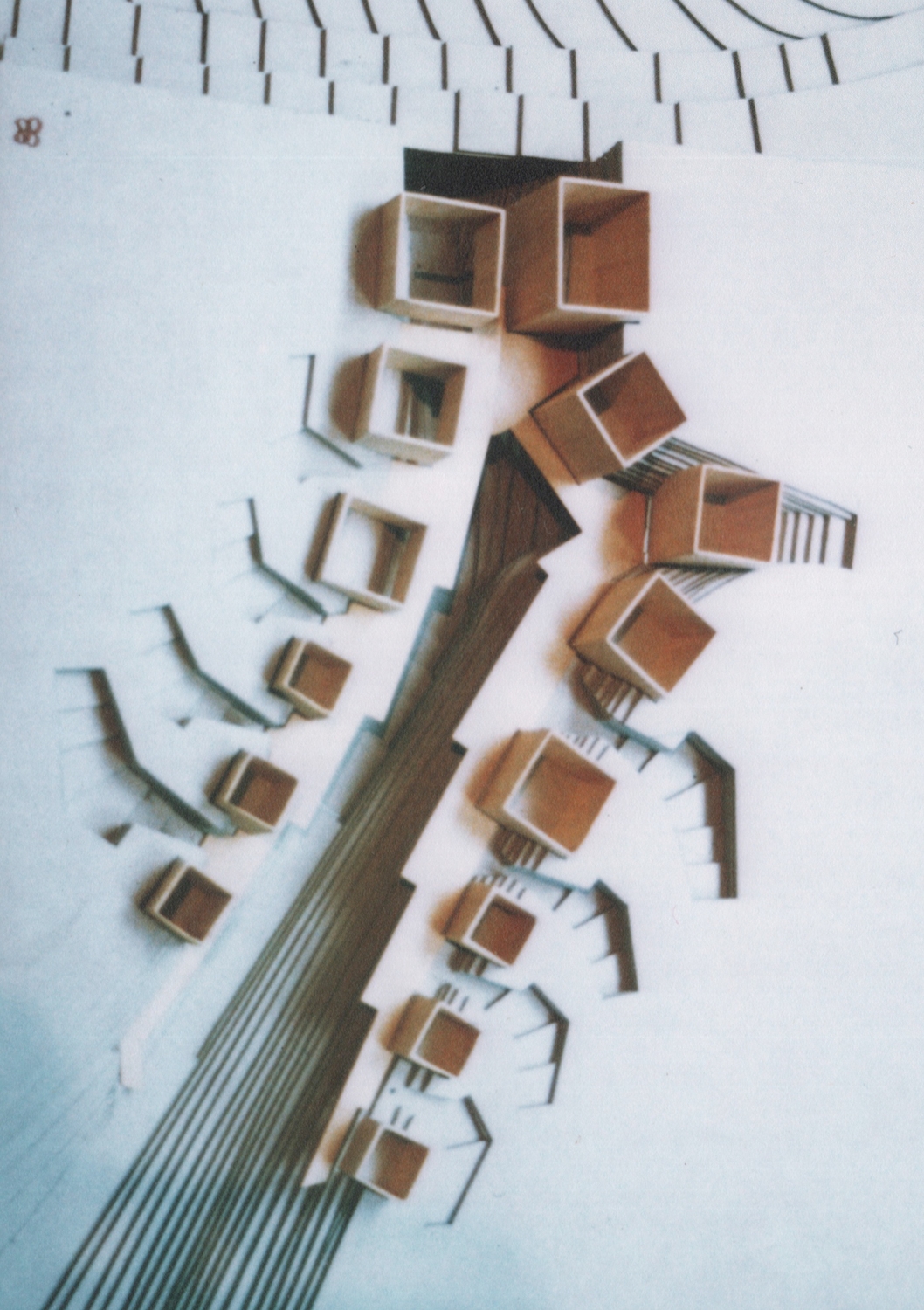
The bee farm yards are a microcosm of the site strategy and are flanked by masters' cabins- echoing the chasm.
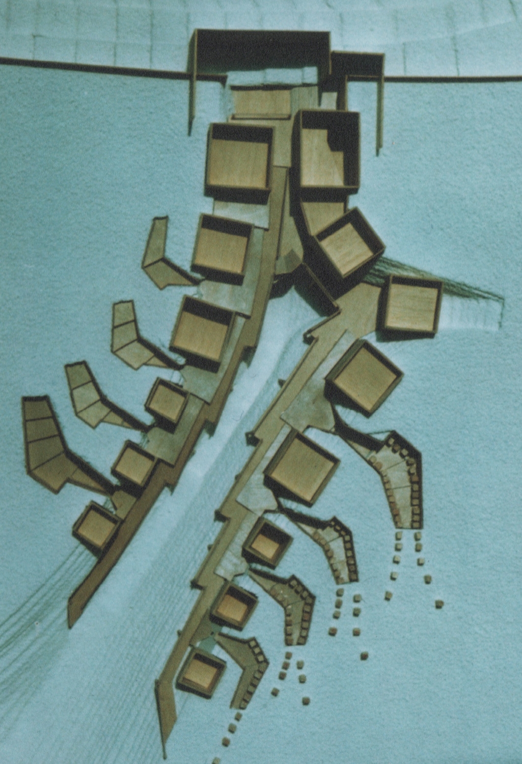
Hives are assembled in the masters' cabins, loaded with bees in the farm yards and placed freestanding on the plateaus.
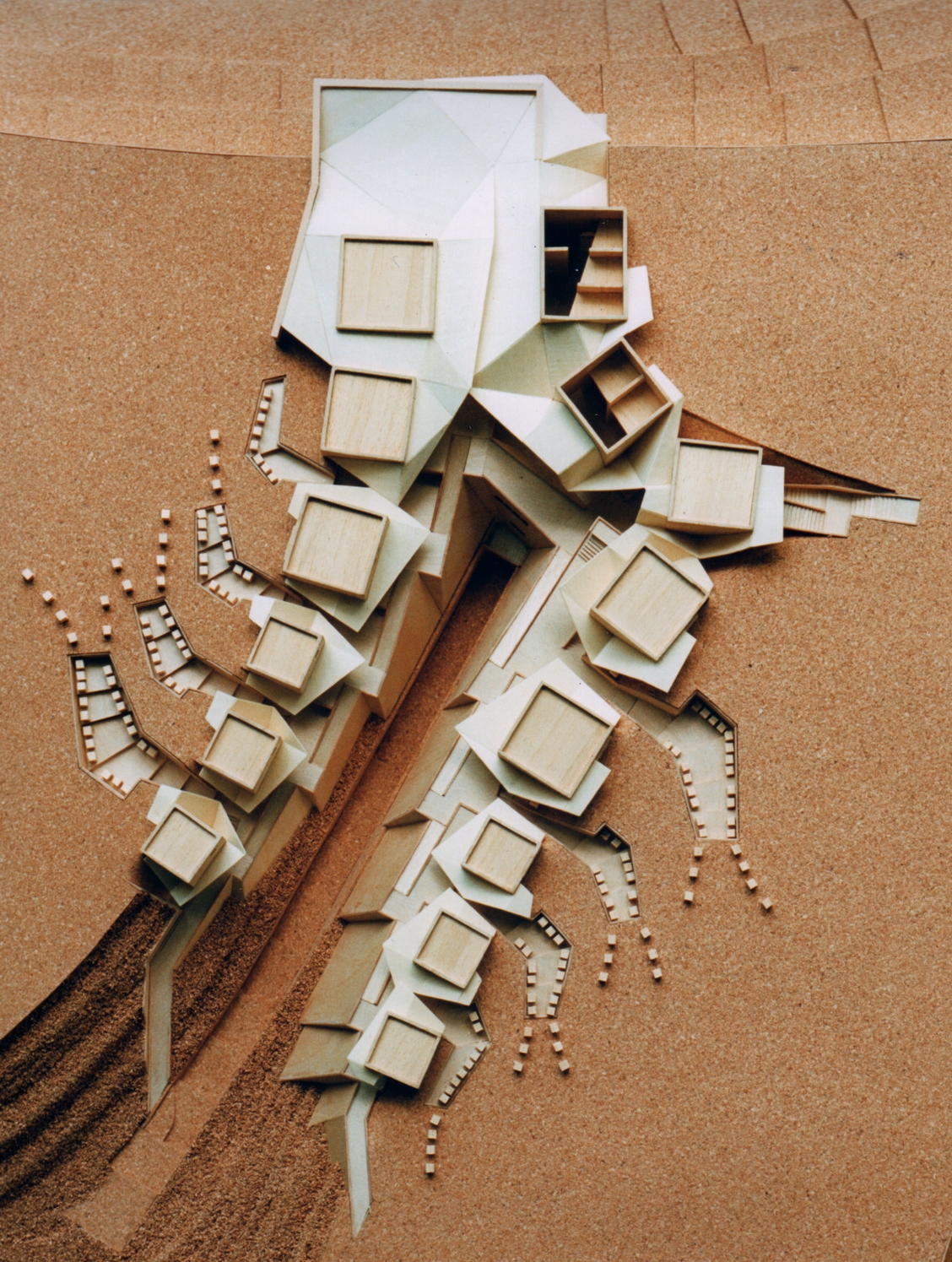
By adding sheet pile, steel ramparts to support the walkways and retain the backfill- The chasm is retained cleanly.

These bee farm yards step up out of the chasm away from the public footpaths into buzzy airspace.
